Geolocate

Dhalai topographic map

Click on the map to display elevation.

Dhalai

The climate in Setrai, which is about 40 km from Ambassa, displays characteristics that are typical of the hilly and mountainous region. The change in the topographical features, heavy rainfall and altitude of the region causes a change in the climatic conditions in Setrai. The climate and other factors of the terrain and the soil are suitable conditions for horticulture.

Wikipedia (CC-BY-SA 3.0)

About this map

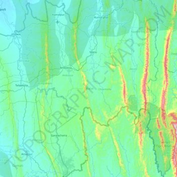
Name: Dhalai topographic map, elevation, terrain.

Location: Dhalai, Tripura, India (23.40625 91.74773 24.24118 92.17587)

Average elevation: 138 m

Minimum elevation: 15 m

Maximum elevation: 1,066 m

Other topographic maps

Click on a map to view its topography, its elevation and its terrain.

Udaipur

India > Tripura > Udaipur

Udaipur is located at 23°32′N 91°29′E / 23.53°N 91.48°E / 23.53; 91.48. It has an average elevation of 22 meters (72 feet)from the sea level. The Gomati river passes through the heart of Udaipur and helps in irrigation of its lands.

Average elevation: 33 m

Udaipur

India > Tripura > Udaipur

Udaipur is located at 23°32′N 91°29′E / 23.53°N 91.48°E / 23.53; 91.48. It has an average elevation of 22 meters (72 feet)from the sea level. The Gomati river passes through the heart of Udaipur and helps in irrigation of its lands.

Average elevation: 33 m

Kadamtala

India > Tripura > Dharmanagar

Average elevation: 27 m

Trishna Wildlife Sanctuary

India > Tripura > Rajnagar

Average elevation: 26 m

Gomati River

India > Tripura > Karbook

Average elevation: 128 m

Ampinagar

India > Tripura > Ompi

Average elevation: 53 m

Amarpur

India > Tripura > Amarpur Urban

Amarpur is located at 23°32′N 91°38′E / 23.53°N 91.64°E / 23.53; 91.64. It has an average elevation of 24 metres (78 feet) above sea level. The town is connected to Udaipur and Teliamura with metalled roads. It can be accessed from the capital city of Agartala via Udaipur town. The nearest…

Average elevation: 54 m

Jirania

India > Tripura > Jirania

Average elevation: 40 m

Udaipur

India > Tripura > Matarbari

Udaipur is located at 23°32′N 91°29′E / 23.53°N 91.48°E / 23.53; 91.48. It has an average elevation of 22 metres (72 feet).The Gomati river passes through the heart of Udaipur and helps in irrigation of its lands.

Average elevation: 33 m

Belonia

India > Tripura > Rajnagar

Average elevation: 20 m

Kakraban

India > Tripura > Kakraban

Average elevation: 21 m

Agartala

India > Tripura > Mohanpur

Average elevation: 23 m

Agartala

India > Tripura > Mohanpur

Average elevation: 23 m

Agartala

India > Tripura > Mohanpur

Average elevation: 23 m

Udaipur

India > Tripura > Matarbari

Udaipur is located at 23°32′N 91°29′E / 23.53°N 91.48°E / 23.53; 91.48. It has an average elevation of 22 metres (72 feet).The Gomati river passes through the heart of Udaipur and helps in irrigation of its lands.

Average elevation: 33 m