
Make a donation
Point Fortin topographic map
Click on the map to display elevation.
Make a donation
Point Fortin
Point Fortin, officially the Republic Borough of Point Fortin, the smallest Borough in Trinidad and Tobago is located in southwestern Trinidad, about 32 km (20 mi) southwest of San Fernando, in the historic county of Saint Patrick. After the discovery of petroleum in the area in 1906 the town grew into a major oil-producing centre. The town grew with the oil industry between the 1940s and 1980s, culminating in its elevation to borough status in 1980. After the end of the oil boom Point Fortin was hit hard by economic recession in the 1980s and the closure of its oil refinery. Construction of a Liquefied Natural Gas plant by Atlantic LNG in late 1990s boosted the economy.
Make a donation
About this map
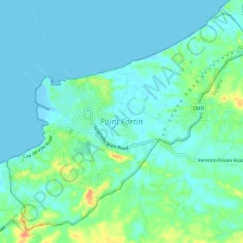
Name: Point Fortin topographic map, elevation, terrain.
Location: Point Fortin, Trinidad and Tobago (10.14100 -61.70764 10.20655 -61.63279)
Average elevation: 9 m
Minimum elevation: -1 m
Maximum elevation: 45 m
Make a donation
Other topographic maps
Click on a map to view its topography, its elevation and its terrain.
Make a donation
Make a donation
Make a donation
Make a donation
Make a donation
Make a donation
Make a donation
Make a donation
Make a donation
Make a donation
Make a donation
Make a donation