Geolocate

Wuzhou topographic map

Interactive map

Click on the map to display elevation.

About this map

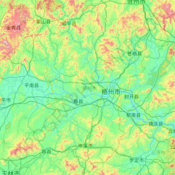
Name: Wuzhou topographic map, elevation, terrain.

Location: Wuzhou, Guangxi, 543000, Chine (22.61098 110.32090 24.40742 111.66148)

Average elevation: 254 m

Minimum elevation: -2 m

Maximum elevation: 1,815 m

Other topographic maps

Click on a map to view its topography, its elevation and its terrain.

Chongzuo

Chine > Guangxi > Chongzuo > 石景林街道

Chongzuo, 石景林街道, 江州区, Chongzuo, Guangxi, Chine

Average elevation: 185 m

Ban Gioc (Detian) waterfall

Chine > Guangxi > Chongzuo > 德天

Ban Gioc (Detian) waterfall, 德天, 大新县, Chongzuo, Guangxi, Chine

Average elevation: 493 m

内格

Chine > Guangxi > Laibin

内格, Laibin, Guangxi, Chine

Average elevation: 341 m

District de Haicheng

Chine > Guangxi > District de Haicheng

District de Haicheng, Beihai, Guangxi, Chine

Average elevation: 2 m

旧屋地岭

Chine > Guangxi > 光坡镇

旧屋地岭, 光坡镇, District de Gangkou, Fangchenggang, Guangxi, Chine

Average elevation: 3 m

西河

Chine > Guangxi > Guilin > 西河

西河, Guilin, Guangxi, Chine

Average elevation: 313 m

Nanning

Chine > Guangxi

Nanning, Guangxi, Chine

Average elevation: 225 m

秀峰区

Chine > Guangxi > 秀峰区

秀峰区, Guilin, Guangxi, Chine

Average elevation: 176 m

弄鲁

Chine > Guangxi > 弄鲁

弄鲁, 都安瑶族自治县, Hechi, Guangxi, Chine

Average elevation: 441 m

Nanning

Chine > Guangxi > Nanning

Nanning, 兴宁区 (Xingning), 南宁市 / Nanning, Guangxi, 460000, Chine

Average elevation: 126 m

那坡县 (Napo)

Chine > Guangxi

那坡县 (Napo), 百色市, Guangxi, Chine

Average elevation: 899 m

Beihai

Chine > Guangxi

Beihai, District de Haicheng, Beihai, Guangxi, Chine

Average elevation: 6 m

Guilin

Chine > Guangxi > Guilin

Guilin, Guangxi, Chine

Average elevation: 477 m