
Bunia topographic map
Interactive map
Click on the map to display elevation.
About this map
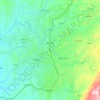
Name: Bunia topographic map, elevation, terrain.
Location: Bunia, Ituri, Democratic Republic of the Congo (1.50098 30.20198 1.60705 30.31717)
Average elevation: 1,273 m
Minimum elevation: 1,156 m
Maximum elevation: 1,636 m
It lies at an elevation of 1,275 metres or 4,180 feet on a plateau about 30 kilometres or 19 miles west of Lake Albert in the Albertine Rift, and about 25 kilometres or 16 miles east of the Ituri Rainforest.
Other topographic maps
Click on a map to view its topography, its elevation and its terrain.
Epau
Democratic Republic of the Congo > Ituri > Aru
Epau, Aru, Ituri, Democratic Republic of the Congo
Average elevation: 1,249 m
Bulo
Democratic Republic of the Congo > Ituri > Djugu
Bulo, Djugu, Ituri, Democratic Republic of the Congo
Average elevation: 2,064 m
Bunia
Democratic Republic of the Congo > Ituri > Bunia
Bunia, Irumu, Orientale, Ituri, Democratic Republic of the Congo
Average elevation: 1,271 m
Lebia
Democratic Republic of the Congo > Ituri > Lebia
Lebia, Orientale, Ituri, Democratic Republic of the Congo
Average elevation: 901 m
Amee
Democratic Republic of the Congo > Ituri > Amee
Amee, Orientale, Ituri, Democratic Republic of the Congo
Average elevation: 1,844 m
Shari
Democratic Republic of the Congo > Ituri > Bunia
Shari, Bunia, Irumu, Orientale, Ituri, Democratic Republic of the Congo
Average elevation: 1,005 m