
Thank you for supporting this site ❤️
Make a donation
Make a donation
Osnabruck topographic map
Click on the map to display elevation.
Thank you for supporting this site ❤️
Make a donation
Make a donation
About this map
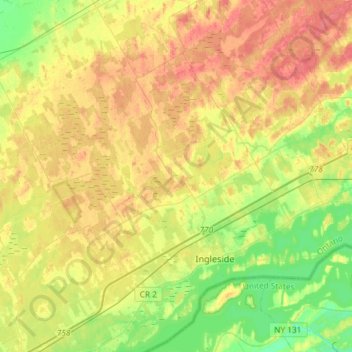
Name: Osnabruck topographic map, elevation, terrain.
Average elevation: 85 m
Minimum elevation: 59 m
Maximum elevation: 110 m
Thank you for supporting this site ❤️
Make a donation
Make a donation
Other topographic maps
Click on a map to view its topography, its elevation and its terrain.
Ingleside
Canada > Ontario > Stormont, Dundas and Glengarry Counties > South Stormont
Average elevation: 78 m
Long Sault
Canada > Ontario > Stormont, Dundas and Glengarry Counties > South Stormont
Average elevation: 77 m