
Thank you for supporting this site ❤️
Make a donation
Make a donation
Fothergill Island topographic map
Click on the map to display elevation.
Thank you for supporting this site ❤️
Make a donation
Make a donation
About this map
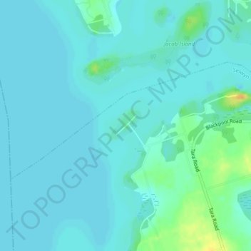
Name: Fothergill Island topographic map, elevation, terrain.
Average elevation: 248 m
Minimum elevation: 243 m
Maximum elevation: 273 m
Thank you for supporting this site ❤️
Make a donation
Make a donation
Other topographic maps
Click on a map to view its topography, its elevation and its terrain.
Thank you for supporting this site ❤️
Make a donation
Make a donation
Curve Lake First Nation
Canada > Ontario > Peterborough County > Selwyn > Young's Point
Average elevation: 247 m