
海淀区 topographic map
Interactive map
Click on the map to display elevation.
About this map
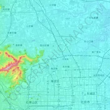
Name: 海淀区 topographic map, elevation, terrain.
Location: 海淀区, 北京市, 中国 (39.88531 116.04255 40.15981 116.38883)
Average elevation: 70 m
Minimum elevation: 24 m
Maximum elevation: 788 m
海淀区系古代永定河冲积扇的一部分,地势西高东低,大部分为海拔 50 米左右的平原。海淀区西部为海拔100米以上的山地,面积约为66平方公里,占总面积的15%左右;东部和南部为海拔50米左右的平原,面积约360平方公里,占总面积的85%左右。最高峰为阳台山妙高峰,海拔1278米;最低处为清河东的黑泉村,海拔35米。土壤大部分为褐土类,适合种植。
Other topographic maps
Click on a map to view its topography, its elevation and its terrain.