
Thank you for supporting this site ❤️
Make a donation
Make a donation
Pekalongan topographic map
Click on the map to display elevation.
Thank you for supporting this site ❤️
Make a donation
Make a donation
About this map
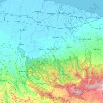
Name: Pekalongan topographic map, elevation, terrain.
Location: Pekalongan, Central Java, Java, Indonesia (-7.24443 109.48343 -6.83935 109.79871)
Average elevation: 402 m
Minimum elevation: -1 m
Maximum elevation: 2,138 m
Thank you for supporting this site ❤️
Make a donation
Make a donation
Other topographic maps
Click on a map to view its topography, its elevation and its terrain.