
Coronation Mountain topographic map
Interactive map
Click on the map to display elevation.
About this map
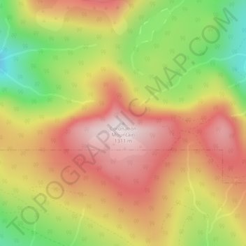
Name: Coronation Mountain topographic map, elevation, terrain.
Average elevation: 1,066 m
Minimum elevation: 767 m
Maximum elevation: 1,305 m
Other topographic maps
Click on a map to view its topography, its elevation and its terrain.
Valdes Island
Canada > British Columbia > Area G (Saltair / Gulf Islands)
Valdes Island, Area G (Saltair / Gulf Islands), Cowichan Valley Regional District, British Columbia, Canada
Average elevation: 11 m
Reid Island
Canada > British Columbia > Area G (Saltair / Gulf Islands)
Reid Island, Area G (Saltair / Gulf Islands), Cowichan Valley Regional District, British Columbia, Canada
Average elevation: 2 m