
Make a donation
Province of Ica topographic map
Click on the map to display elevation.
Make a donation
About this map
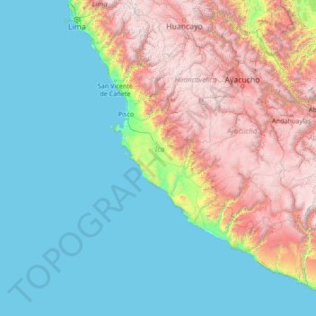
Name: Province of Ica topographic map, elevation, terrain.
Location: Province of Ica, Peru (-16.93861 -78.24833 -11.73861 -73.04833)
Average elevation: 1,319 m
Minimum elevation: 0 m
Maximum elevation: 5,501 m
Make a donation
Other topographic maps
Click on a map to view its topography, its elevation and its terrain.
Quelccaya
The Andes in Peru, Ecuador, and Bolivia are subdivided into several separate mountain ranges, many of which are glaciated above 5,000 metres (16,000 ft) elevation; Peru contains about 70% of all tropical glaciers. Together with the Coropuna volcano also in southern Peru and ice bodies in New Guinea and the…
Average elevation: 5,167 m
Make a donation
Make a donation
Machu Picchu
Peru > Cusco > Machupicchu > San Miguel
Animals are also suspected to have immigrated to Machu Picchu as there were several bones found that were not native to the area. Most animal bones found were from llamas and alpacas. These animals naturally live at altitudes of 4,000 metres (13,000 ft) rather than the 2,400 metres (7,900 ft) elevation of…
Average elevation: 2,227 m
Make a donation
Make a donation
Make a donation
Make a donation
Make a donation
Vilcabamba
Vilcabamba District is one of fourteen districts of the La Convención Province in the Cusco Region in Peru. The capital of the province is the Centro Poblado Lucma, which has an elevation of 2,943 metres (9,656 ft). Vitcos was an important city of the Neo-Inca State (1537-1572). Its ruins are now preserved as…
Average elevation: 2,770 m
Make a donation
Make a donation
Mato
The district is located in the west-central part of the province at an elevation of 2,239m in the black mountains (Spanish: Cordillera Negra), neighboring district is the Caraz district in which the provinces capital Caraz is located, 12 km from the village of Villa Sucre. The regions capital Huaraz is located…
Average elevation: 3,455 m
Make a donation
Huascarán National Park
Huascarán National Park protects the Cordillera Blanca, which is the world's highest tropical mountain range. Located in the central Peruvian Andes, the park's 340,000 hectares (840,000 acres) cover an elevational range from around 2,500 meters (8,200 ft) to the several snow-capped peaks above 6,000 meters…
Average elevation: 3,681 m
Make a donation
Make a donation
Province of Yungay
The Cordillera Blanca and the Cordillera Negra traverse the province. Waskaran, the highest elevation of Peru, lies on the border with the province of Carhuaz. Chakrarahu, Chopicalqui, Tullparahu and Yanarahu (Ruriqucha) belong to the highest peaks of the province. Other mountains are listed below.
Average elevation: 3,808 m
Make a donation
Make a donation
Sacsayhuamán
Peru > Cusco > Cuzco > Mollococha
Sacsayhuamán (/ˈsæksaɪˌwʌmən/ SACK-sy-wuh-mən; Spanish pronunciation: [saksajwaˈman]) or Saksaywaman (from Quechua Saksay waman pukara, pronounced [ˈsaksaj ˈwaman], lit. 'fortress of the royal falcon or hawk') is a citadel on the northern outskirts of the city of Cusco, Peru, the historic capital…
Average elevation: 3,578 m
Make a donation
Sacred Valley of the Incas
The valley, running generally west to east, is understood to include everything along the Urubamba River between the town and Inca ruins at Písac and Machu Picchu, 100 kilometres (62 mi) distant. The Sacred Valley has elevations above sea level along the river ranging from 3,000 metres (9,800 ft) at Pisac to…
Average elevation: 3,808 m
Make a donation
Ica
Ica has significant wine and pisco industries, annual fiestas, a museum and historic colonial churches. The climate is generally sunny and dry due to its elevation above coastal fog and mist. As of 2020, the Peruvian desert, around the Huacachina Oasis, has gotten significantly popular among tourists for…
Average elevation: 1,624 m
Make a donation
Santo Toribio
The district is located in the north-western part of the province at an elevation of 2,860m.
Average elevation: 3,095 m
Make a donation
Junín
The region has a very heterogeneous topography. The western range located near the border with the Lima Region, has snowy and ice-covered peaks. On the east, there are high glacier valleys which end up in high plateaus (Altiplano). Among them is the Junín Plateau that is located between the cities of La Oroya…
Average elevation: 2,657 m
Make a donation
Make a donation
Los Pantanos de Villa Wildlife Refuge
Pantanos de Villa Wildlife Refuge consists of a series of brackish water lagoons and marshes. These wetlands are formed by the filtration and discharge of water from the Ate-Surco-Chorrillos irrigation canal (which branches off from the Rimac River) and other underground canals. Elevational range inside the…
Average elevation: 11 m
Make a donation
Make a donation
Make a donation
Make a donation
Make a donation