
จังหวัดราชบุรี topographic map
Interactive map
Click on the map to display elevation.
About this map
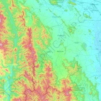
Name: จังหวัดราชบุรี topographic map, elevation, terrain.
Location: จังหวัดราชบุรี, Thailand (13.14898 99.16359 13.94441 100.07832)
Average elevation: 277 m
Minimum elevation: 4 m
Maximum elevation: 1,239 m
Other topographic maps
Click on a map to view its topography, its elevation and its terrain.
ทุ่งหลวง
Thailand > จังหวัดราชบุรี > ทุ่งหลวง
ทุ่งหลวง, จังหวัดราชบุรี, Thailand
Average elevation: 41 m