
Make a donation
Bagmati Province topographic map
Click on the map to display elevation.
Make a donation
Bagmati Province
Bagmati Province has an area of 20,300 km2 which is about 13.79% of the total area of Nepal. The elevation of the province ranges from 141 m at Golaghat in Chitwan District to 7,422m at Ganesh Himal. The province has an altitude low enough to support deciduous, coniferous, and alpine forests and woodlands. 27.29% land is covered by forest. The temperature varies with altitude. There are 10 sub-basins and 33 major rivers flowing through the province. The longest river is the Sunkoshi measuring 160.19 km.
Make a donation
About this map
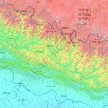
Name: Bagmati Province topographic map, elevation, terrain.
Location: Bagmati Province, Nepal (26.91907 83.91936 28.38583 86.57265)
Average elevation: 2,234 m
Minimum elevation: 54 m
Maximum elevation: 8,647 m
Make a donation
Other topographic maps
Click on a map to view its topography, its elevation and its terrain.
Make a donation
Khumjung
Nepal > Koshi Province > Solukhumbu
Khumjung (Nepali: खुम्जुंग) is a village in Khumbu Pasanglhamu rural municipality of Solukhumbu District in Province No. 1 of north-eastern Nepal. It is located in the Khumbu subregion inside Sagarmatha National Park, a world heritage site. The village is at an elevation of 3,790 metres above…
Average elevation: 3,888 m
Western Development Region
The Western Development Region (Nepali: पश्चिमाञ्चल विकास क्षेत्र, Pashchimānchal Bikās Kshetra) was one of Nepal's five development regions. It was located in the west-central part of the country, with its headquarters located in Pokhara. This Development Region…
Average elevation: 2,742 m
Make a donation
Mount Everest
Nepal > Koshi Province > Solukhumbu
Mount Everest (Nepali: सगरमाथा, romanized: Sagarmāthā; Tibetan: Chomolungma ཇོ་མོ་གླང་མ; Chinese: 珠穆朗玛峰; pinyin: Zhūmùlǎngmǎ Fēng) is Earth's highest mountain above sea level, located in the Mahalangur Himal sub-range of the Himalayas. The China–Nepal…
Average elevation: 7,850 m