
Seeland topographic map
Interactive map
Click on the map to display elevation.
About this map
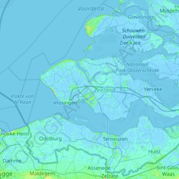
Name: Seeland topographic map, elevation, terrain.
Location: Seeland, Niederlande (51.20016 3.30794 51.78152 4.27742)
Average elevation: 1 m
Minimum elevation: -6 m
Maximum elevation: 42 m
Other topographic maps
Click on a map to view its topography, its elevation and its terrain.
Renesse
Niederlande > Seeland > Renesse
Renesse, Schouwen-Duiveland, Seeland, Niederlande
Average elevation: 1 m