
Wuhu topographic map
Interactive map
Click on the map to display elevation.
About this map
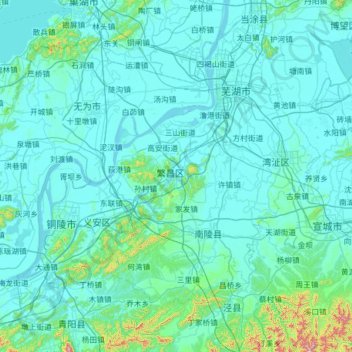
Name: Wuhu topographic map, elevation, terrain.
Location: Wuhu, Anhui, Chine (30.64150 117.48379 31.54044 118.72815)
Average elevation: 57 m
Minimum elevation: -1 m
Maximum elevation: 1,012 m
Other topographic maps
Click on a map to view its topography, its elevation and its terrain.
蓝田镇
Chine > Anhui > Xian de Xiuning > Huangshan
蓝田镇, Xian de Xiuning, Huangshan, Anhui, Chine
Average elevation: 420 m
黄山国家风景名胜区
Chine > Anhui > District de Huangshan
黄山国家风景名胜区, 黄山风景区, District de Huangshan, Huangshan, Anhui, Chine
Average elevation: 754 m
District de Tunxi
District de Tunxi, Huangshan, Anhui, Chine
Average elevation: 166 m