
Make a donation
Apsarasas III topographic map
Click on the map to display elevation.
Make a donation
About this map
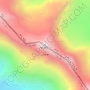
Name: Apsarasas III topographic map, elevation, terrain.
Average elevation: 6,272 m
Minimum elevation: 5,383 m
Maximum elevation: 6,943 m
Make a donation
Other topographic maps
Click on a map to view its topography, its elevation and its terrain.
Alar National Wetland Park
China > Xinjiang > Taxkorgan Tajik Autonomous County > Tashkorgan Town > 瓦尔希迭村 ۋەرشىدې
Average elevation: 3,074 m
Toyun Township
China > Xinjiang > Ulugqat County
The seat of Tuoyun Township is at 2,780 meters above sea level. The average elevation of the township is above 3,300 meters. The highest altitude is 5,031 meters. The altitude of each pasture is 3,000-4,500 meters. More than 98% are Gobi desert and saline-alkali land, and the climate is extremely bad. The…
Average elevation: 3,537 m
Make a donation
Make a donation
Ulugqat County
There are 11 local ethnic groups in the county, such as Kyrgyz, Han, Uyghur, Hui, Uzbek, Tajik, etc. and the Kyrgyz ethnic group accounts for about 80% of the total population of the county. Its total land area of the county is 19,118 square kilometers with an average elevation of 2,890 meters and its county…
Average elevation: 3,049 m
Yarkant County
Yarkant County, also Shache County, also transliterated from Uyghur as Yakan County, is a county in the Xinjiang, China, located on the southern rim of the Taklamakan Desert in the Tarim Basin. It is one of 11 counties administered under Kashgar Prefecture. The county, usually referred to as Yarkand in…
Average elevation: 1,709 m
Make a donation
Taxkorgan Tajik Autonomous County
The territorial expanse of the county is 178 kilometres (111 mi) from north to south and 140 kilometres (87 mi) from east to west, the total area is about 25,000 square kilometres (9,700 sq mi), with an average altitude above 4,000 metres (13,000 ft). The county includes a significant part of the…
Average elevation: 3,931 m
Ürümqi
The largest city in western China, Ürümqi has earned a place in the Guinness Book of Records as the most remote city from any sea in the world. It is about 2,500 kilometres (1,600 mi) from the nearest coastline as Ürümqi is the closest major city to the Eurasian pole of inaccessibility, although Karamay…
Average elevation: 1,294 m
Ruoqiang County
The county seat is in Ruoqiang Town. This is the location which less-detailed maps will label as "Ruoqiang". It lies at an altitude of 848 metres (2,782 ft).
Average elevation: 2,588 m
Make a donation
Make a donation
Ürümqi
The largest city in western China, Ürümqi has earned a place in the Guinness Book of Records as the most remote city from any sea in the world. It is about 2,500 kilometres (1,600 mi) from the nearest coastline as Ürümqi is the closest major city to the Eurasian pole of inaccessibility, although Karamay…
Average elevation: 1,294 m
Make a donation
Hemu River
China > Xinjiang > Burqin County > Kom-Kanas Mongolian Ethnic Township
Average elevation: 1,732 m
Make a donation
Ürümqi
The largest city in western China, Ürümqi has earned a place in the Guinness Book of Records as the most remote city from any sea in the world. It is about 2,500 kilometres (1,600 mi) from the nearest coastline as Ürümqi is the closest major city to the Eurasian pole of inaccessibility, although Karamay…
Average elevation: 1,294 m
Make a donation
Make a donation
Make a donation
Ürümqi
The largest city in western China, Ürümqi has earned a place in the Guinness Book of Records as the most remote city from any sea in the world. It is about 2,500 kilometres (1,600 mi) from the nearest coastline as Ürümqi is the closest major city to the Eurasian pole of inaccessibility, although Karamay…
Average elevation: 1,294 m
Make a donation
Tashkorgan Town
China > Xinjiang > Taxkorgan Tajik Autonomous County
Stein argued that, judging from the topography and remains found around Tashkurgan, the fort and associated settlements had clearly been central to the broader Sarikol area, controlling routes from the Oxus to the oases of southern Turkestan.
Average elevation: 3,109 m
Make a donation
Make a donation
Make a donation
Akqi County
The name of Akqi was from the Kyrgyz language, meaning white achnatherum calamagrostis (白芨芨草). The Administrative Division of Akqi (阿合奇设治局) was first established, it was named after its seat located in the Village of Akqi (阿合奇村). The county of Akqi is located in alpine areas of the…
Average elevation: 2,812 m
Make a donation
Dafdar
China > Xinjiang > Taxkorgan Tajik Autonomous County
Dafdar village lies at an altitude of 3,400 m above sea level, just to the east of the Karakoram Highway.
Average elevation: 4,416 m
Make a donation
Make a donation
Make a donation
Make a donation
Make a donation
Karamay City
Karamay is located in the northwest of the Dzungarian basin, with an average elevation of 400 meters (1,300 ft). Its administrative area ranges in latitude from 44° 07' to 46° 08' N and in longitude from 80° 44' to 86° 01' E and has a maximal 240 km (150 mi) north–south extent and reaches 110 km (68 mi)…
Average elevation: 633 m
Make a donation