
Albite topographic map
Interactive map
Click on the map to display elevation.
About this map
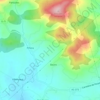
Name: Albite topographic map, elevation, terrain.
Location: Albite, Llanera, Asturias, 33424, España (43.43450 -5.89011 43.45450 -5.87011)
Average elevation: 217 m
Minimum elevation: 142 m
Maximum elevation: 389 m
Other topographic maps
Click on a map to view its topography, its elevation and its terrain.
Santolaya / Soto de Llanera
España > Asturias > Llanera > Santolaya / Soto de Llanera
Santolaya / Soto de Llanera, Llanera, Asturias, 33423, España
Average elevation: 203 m
Posada de Llanera
Posada de Llanera, Llanera, Asturias, 33424, España
Average elevation: 207 m
Prubia
España > Asturias > Llanera > Santolaya / Soto de Llanera > Prubia de Abajo
Prubia, Prubia de Abajo, Santolaya / Soto de Llanera, Llanera, Asturias, 33423, España
Average elevation: 198 m