
Thank you for supporting this site ❤️
Make a donation
Make a donation
Jost Van Dyke topographic map
Click on the map to display elevation.
Thank you for supporting this site ❤️
Make a donation
Make a donation
About this map
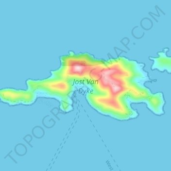
Name: Jost Van Dyke topographic map, elevation, terrain.
Location: Jost Van Dyke, British Virgin Islands (18.43504 -64.78148 18.45852 -64.72072)
Average elevation: 23 m
Minimum elevation: 0 m
Maximum elevation: 308 m
Thank you for supporting this site ❤️
Make a donation
Make a donation
Other topographic maps
Click on a map to view its topography, its elevation and its terrain.