
Make a donation
Chiang Mai topographic map
Click on the map to display elevation.
Make a donation
Chiang Mai
The city is situated in a valley on a river basin in the Thai highlands and is on average at 300 m (1,000 ft) elevation. Chiang Mai's city centre sits west of the Ping River, a tributary to the Chao Phraya River, while the city's sprawl extends north-west, south-west, north-east and east of the river. To the west side of Chiang Mai lies the Thanon Thong Chai Mountain Range, with one major peak, Doi Suthep mountain, prominently rising above the city with an elevation of 1,676 metres (5,499 ft).
Make a donation
About this map
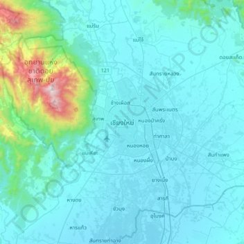
Name: Chiang Mai topographic map, elevation, terrain.
Average elevation: 424 m
Minimum elevation: 291 m
Maximum elevation: 1,670 m
Make a donation
Other topographic maps
Click on a map to view its topography, its elevation and its terrain.
Make a donation
Thailand
Thailand comprises several distinct geographic regions, partly corresponding to the provincial groups. The north of the country is the mountainous area of the Thai highlands, with the highest point being Doi Inthanon in the Thanon Thong Chai Range at 2,565 metres (8,415 ft) elevation. The northeast, Isan,…
Average elevation: 156 m
Chiang Mai Province
Chiang Mai province is about 685 km (426 mi) from Bangkok in the Mae Ping River basin and is on average at 300 m (1,000 ft) elevation. Surrounded by the mountain ranges of the Thai highlands, it covers an area of approximately 22,135 km2 (9,000 sq mi). The mountains of the Daen Lao Range…
Average elevation: 649 m
Make a donation
Kanchanaburi Province
Thailand > Kanchanaburi Province
The province is in the west of Thailand, 129 km from Bangkok, and covers a total area of approximately 19,483 km². It is the country's third largest province, after Nakhon Ratchasima and Chiang Mai. Topographically, it is covered with timber and evergreen forests. The district covers the source valleys of the…
Average elevation: 297 m
Chaiyaphum Province
Thailand > Chaiyaphum Province
The province is bisected by the Phetchabun mountain range, with the highest elevation in the province at 1,222 m. The east of the province is part of the Khorat Plateau.
Average elevation: 317 m
Nakhon Nayok Province
Thailand > Nakhon Nayok Province
The northern part of the province is in the Sankamphaeng Range, the southern prolongation of the Dong Phaya Yen mountains, with the highest elevation the 1,292-meter-high Yod Khao Kiew. Most of that area is covered by the Khao Yai National Park. The total forest area is 642 km2 (248 sq mi) or 30 percent of…
Average elevation: 183 m
Maha Phram Subdistrict Municipality
Thailand > Phra Nakhon Si Ayutthaya Province > Bang Ban District
Average elevation: 5 m
Make a donation
Make a donation