
Make a donation
Peter Peak topographic map
Click on the map to display elevation.
Make a donation
About this map
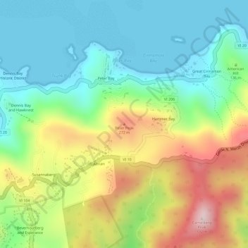
Name: Peter Peak topographic map, elevation, terrain.
Average elevation: 129 m
Minimum elevation: 0 m
Maximum elevation: 342 m
Make a donation
Other topographic maps
Click on a map to view its topography, its elevation and its terrain.
Little Saint James Island
United States > United States Virgin Islands > Saint Thomas - Saint John District
Average elevation: 1 m
Saint John
United States > United States Virgin Islands > Saint Thomas - Saint John District > East End
Average elevation: 26 m
Saint Thomas
United States > United States Virgin Islands > Saint Thomas - Saint John District > Charlotte Amalie
Average elevation: 15 m
Little Saint James Island
United States > United States Virgin Islands > Saint Thomas - Saint John District
Average elevation: 1 m
Make a donation
Little Saint James Island
United States > United States Virgin Islands > Saint Thomas - Saint John District
Average elevation: 1 m
Saint John
United States > United States Virgin Islands > Saint Thomas - Saint John District > East End
Average elevation: 26 m
Little Saint James Island
United States > United States Virgin Islands > Saint Thomas - Saint John District
Average elevation: 1 m
Little Saint James Island
United States > United States Virgin Islands > Saint Thomas - Saint John District
Average elevation: 1 m
Make a donation
Saint John
United States > United States Virgin Islands > Saint Thomas - Saint John District > East End
Average elevation: 26 m
Saint John
United States > United States Virgin Islands > Saint Thomas - Saint John District > Coral Harbour
Average elevation: 26 m
Charlotte Amalie
United States > United States Virgin Islands > Saint Thomas - Saint John District > Charlotte Amalie
Average elevation: 60 m
Saint Thomas
United States > United States Virgin Islands > Saint Thomas - Saint John District > Charlotte Amalie
Average elevation: 15 m
Make a donation
Saint John
United States > United States Virgin Islands > Saint Thomas - Saint John District > East End
Average elevation: 26 m
Saint John
United States > United States Virgin Islands > Saint Thomas - Saint John District > East End
Average elevation: 26 m
Saint Thomas
United States > United States Virgin Islands > Saint Thomas - Saint John District > Charlotte Amalie
Average elevation: 15 m
Saint Thomas
United States > United States Virgin Islands > Saint Thomas - Saint John District > Charlotte Amalie
Average elevation: 15 m
Make a donation
Charlotte Amalie West
United States > United States Virgin Islands > Saint Thomas - Saint John District
Average elevation: 40 m
Charlotte Amalie
United States > United States Virgin Islands > Saint Thomas - Saint John District > Charlotte Amalie
Average elevation: 60 m
Saint John
United States > United States Virgin Islands > Saint Thomas - Saint John District > East End
Average elevation: 26 m
Saint Thomas
United States > United States Virgin Islands > Saint Thomas - Saint John District > Charlotte Amalie
Average elevation: 15 m
Make a donation
Saint Thomas
United States > United States Virgin Islands > Saint Thomas - Saint John District > Charlotte Amalie
Average elevation: 15 m
Water Island
United States > United States Virgin Islands > Saint Thomas - Saint John District
Average elevation: 7 m
Saint Thomas
United States > United States Virgin Islands > Saint Thomas - Saint John District > Charlotte Amalie
Average elevation: 15 m
Anna's Retreat
United States > United States Virgin Islands > Saint Thomas - Saint John District
Average elevation: 99 m
Make a donation
Saint John
United States > United States Virgin Islands > Saint Thomas - Saint John District > East End
Average elevation: 26 m
Charlotte Amalie
United States > United States Virgin Islands > Saint Thomas - Saint John District > Charlotte Amalie
Average elevation: 68 m