
Make a donation
Charlotte Amalie West topographic map
Click on the map to display elevation.
Make a donation
About this map
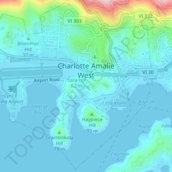
Name: Charlotte Amalie West topographic map, elevation, terrain.
Average elevation: 40 m
Minimum elevation: -1 m
Maximum elevation: 295 m
Make a donation
Other topographic maps
Click on a map to view its topography, its elevation and its terrain.
Little Saint James Island
United States > United States Virgin Islands > Saint Thomas - Saint John District
Average elevation: 1 m
Little Saint James Island
United States > United States Virgin Islands > Saint Thomas - Saint John District
Average elevation: 1 m
Coral Bay
United States > United States Virgin Islands > Saint Thomas - Saint John District
Average elevation: 84 m
Peter Peak
United States > United States Virgin Islands > Saint Thomas - Saint John District
Average elevation: 129 m
Make a donation
Cruz Bay
United States > United States Virgin Islands > Saint Thomas - Saint John District
Average elevation: 24 m
Charlotte Amalie West
United States > United States Virgin Islands > Saint Thomas - Saint John District > Charlotte Amalie
Average elevation: 52 m
Central
United States > United States Virgin Islands > Saint Thomas - Saint John District
Average elevation: 174 m
Water Island
United States > United States Virgin Islands > Saint Thomas - Saint John District
Average elevation: 7 m
Make a donation
Fortuna
United States > United States Virgin Islands > Saint Thomas - Saint John District
Average elevation: 40 m
Charlotte Amalie
United States > United States Virgin Islands > Saint Thomas - Saint John District > Charlotte Amalie
Average elevation: 62 m