
Make a donation
Barkly East topographic map
Click on the map to display elevation.
Make a donation
Barkly East
Barkly East (Afrikaans: Barkly-Oos) is a town in Eastern Cape Province, South Africa, seat of the Joe Gqabi District Municipality, and 117 km by road E.S.E. of Aliwal North, lying in the mountainous area just south of Lesotho. The town lies at the southern tip of the Drakensberg on the Langkloofspruit, a tributary of the Kraai River which, in turn is a tributary of the Orange River at an elevation of 1 790 meter (5 873 foot) above sealevel. Barkly East is characterized by rugged mountains and green valleys. Snow falls in winter, and the hamlet of Rhodes is 60 km or an hour's drive from Barkly East on the R396. Both are within the boundaries of the Senqu Local Municipality.
Make a donation
About this map
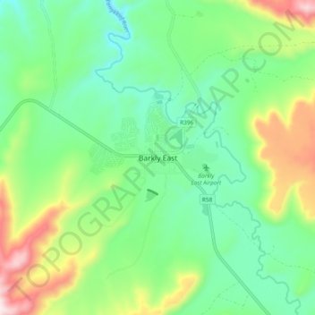
Name: Barkly East topographic map, elevation, terrain.
Average elevation: 1,838 m
Minimum elevation: 1,658 m
Maximum elevation: 2,234 m
Make a donation
Other topographic maps
Click on a map to view its topography, its elevation and its terrain.
Rhodes
South Africa > Eastern Cape > Joe Gqabi District Municipality > Senqu Local Municipality
Average elevation: 2,067 m