
Make a donation
London topographic map
Click on the map to display elevation.
Make a donation
London
London has a humid continental climate (Köppen Dfb), though due to its downwind location relative to Lake Huron and elevation changes across the city, it is virtually on the Dfa/Dfb (hot summer) boundary favouring the former climate zone to the southwest of the confluence of the South and North Thames Rivers, and the latter zone to the northeast (including the airport). Because of its location in the continent, London experiences large seasonal contrast, tempered to a point by the surrounding Great Lakes. The summers are usually warm to hot and humid, with a July average of 20.8 °C (69.4 °F), and temperatures above 30 °C (86 °F) occur on average 10 days per year. In 2016, however, temperatures at or above 30 °C (86 °F) occurred more than 35 times, and in 2018, four heatwave incidents led to humidex temperatures topping out at 46 °C (115 °F) . The city is affected by frequent thunderstorms due to hot, humid summer weather, as well as the convergence of breezes originating from Lake Huron and Lake Erie. The same convergence zone is responsible for spawning funnel clouds and the occasional tornado. Spring and autumn in between are not long, and winters are cold but witness frequent thaws. Annual precipitation averages 1,011.5 mm (39.82 in). Its winter snowfall totals are heavy, averaging about 194 cm (76 in) per year, although the localized nature of snow squalls means the total can vary widely from year to year. Some of the snow accumulation comes from lake effect snow and snow squalls originating from Lake Huron, some 60 km (37 mi) to the northwest, which occurs when strong, cold winds blow from that direction. From 5 December 2010, to 9 December 2010, London experienced record snowfall when up to 2 m (79 in) of snow fell in parts of the city. Schools and businesses were closed for three days and bus service was cancelled after the second day of snow.
Make a donation
About this map
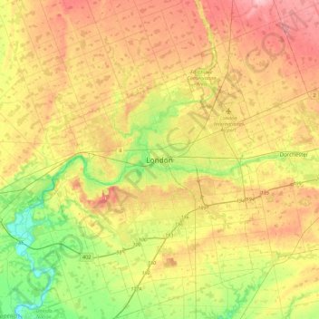
Name: London topographic map, elevation, terrain.
Location: London, Southwestern Ontario, Ontario, N6A 3N7, Canada (42.82324 -81.40337 43.14324 -81.08337)
Average elevation: 269 m
Minimum elevation: 203 m
Maximum elevation: 340 m
Make a donation
Other topographic maps
Click on a map to view its topography, its elevation and its terrain.
Biscotasi Lake
Canada > Ontario > Sudbury District > Unorganized North Sudbury
Average elevation: 416 m
Make a donation
Kitchener
Canada > Ontario > Region of Waterloo
Kitchener is located in Southwestern Ontario, in the Saint Lawrence Lowlands. This geological and climatic region has wet-climate soils and deciduous forests. Situated in the Grand River Valley, the area is generally above 300 m (1,000 ft) in elevation.
Average elevation: 336 m
Make a donation
Newmarket
Canada > Ontario > York Region
Newmarket's geographical coordinates are 44.05°N, 79.46°W, and its elevation above sea level is 252 m. It has an area of 38.33 km2. The town is bounded on the south by Aurora, on the west by King, on the north by East Gwillimbury and on the east by Whitchurch–Stouffville.
Average elevation: 270 m
Make a donation
Make a donation
Make a donation
Make a donation
King Lake
Canada > Ontario > Timiskaming District > Unorganized West Timiskaming > King Kirkland
Average elevation: 343 m
Make a donation
Make a donation
Make a donation
St. Catharines
Canada > Ontario > Niagara Region
The most defining transportation icon of St. Catharines is the Welland Canal, a ship canal that runs 43.4 kilometres (27.0 mi), passing through the city. Four of its locks are within city boundaries. The canal allows shipping vessels to traverse the 99.5-metre (326.5 ft) drop in altitude from Lake Erie to Lake…
Average elevation: 103 m
Wasaga Beach Provincial Park
Canada > Ontario > Simcoe County > Wasaga Beach
The Town of Wasaga Beach covers an area of 61.13 square kilometres (23.60 sq mi) comprised predominantly of sand and loamy sand that exhibit excessive to good drainage and irregular to moderately sloping topography. The poor soil quality makes it difficult to sustain lush lawns in the town. The Canada Land…
Average elevation: 185 m
Make a donation
Make a donation
Make a donation
Make a donation
Make a donation
Shall Lake
Canada > Ontario > Nipissing District > Unorganized South Nipissing
Average elevation: 417 m
Make a donation
Make a donation