
Make a donation
Hubei topographic map
Click on the map to display elevation.
Make a donation
Hubei
The Jianghan Plain takes up most of central and southern Hubei, while the west and the peripheries are more mountainous, with ranges such as the Wudang Mountains, the Jing Mountains, the Daba Mountains, and the Wu Mountains (in rough north-to-south order). The Dabie Mountains lie to the northeast of the Jianghan Plain, on the border with Henan and Anhui; the Tongbai Mountains lie to the north on the border with Henan; to the southeast, the Mufu Mountains form the border with Jiangxi. The highest peak in Hubei is Shennong Peak, found in the Daba Mountains of the forestry area of Shennongjia; it has an altitude of 3105 m.
Make a donation
About this map
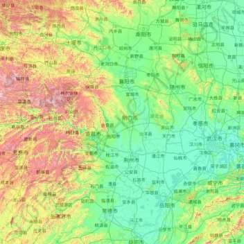
Name: Hubei topographic map, elevation, terrain.
Location: Hubei, China (28.40000 109.40000 33.60000 114.60000)
Average elevation: 417 m
Minimum elevation: 9 m
Maximum elevation: 3,007 m
Make a donation
Other topographic maps
Click on a map to view its topography, its elevation and its terrain.
Hong Kong
Hong Kong has a humid subtropical climate (Köppen Cwa), characteristic of southern China, despite being located south of the Tropic of Cancer. Summer is hot and humid, with occasional showers and thunderstorms and warm air from the southwest. Typhoons occur most often then, sometimes resulting in floods or…
Average elevation: 47 m
Make a donation
Yunnan
Yunnan is situated in a mountainous area, with high elevations in the northwest and low elevations in the southeast. Most of the population lives in the eastern part of the province. In the west, the altitude can vary from the mountain peaks to river valleys by as much as 3,000 m (9,800 ft). Yunnan is rich in…
Average elevation: 1,713 m
Hong Kong
Hong Kong has a humid subtropical climate (Köppen Cwa), characteristic of southern China, despite being located south of the Tropic of Cancer. Summer is hot and humid, with occasional showers and thunderstorms and warm air from the southwest. Typhoons occur most often then, sometimes resulting in floods or…
Average elevation: 47 m
Make a donation
Kunming
Kunming (/kʊnˈmɪŋ/;[3] Chinese: 昆明; pinyin: Kūnmíng), also known as Yunnan-Fu, is the capital and largest city of Yunnan province, China.[4] It is the political, economic, communications and cultural centre of the province as well as the seat of the provincial government. The headquarters of many of…
Average elevation: 1,463 m
Make a donation
Make a donation
Sichuan
Due to great differences in terrain, the climate of the province is highly variable. In general, it has strong monsoonal influences, with rainfall heavily concentrated in the summer. Under the Köppen climate classification, the Sichuan Basin (including Chengdu) in the eastern half of the province experiences…
Average elevation: 2,522 m
Make a donation
Jingdezhen
Jingdezhen is situated in the north-east of Jiangxi and borders on Anhui; the city center area is located in the north-east of the Poyang Lake Plain. Its area is 5,256 km2 (2,029 sq mi). The highest point is 1,618 m (5,308 ft), with plains on the southern part having an average altitude of 200 m (660 ft).
Average elevation: 167 m
Beijing
Beijing is situated at the northern edge of the roughly triangular North China Plain, which opens to the south and east of the city. Mountains to the north, northwest and west shield the city and northern China's agricultural heartland from the encroaching desert steppes. The northwestern part of the…
Average elevation: 460 m
Taipa Central Park
China > Macau > 嘉模堂區 Nossa Senhora do Carmo > 花城 Cidade das Flores
Average elevation: 11 m
Make a donation
Yunnan
Yunnan is situated in a mountainous area, with high elevations in the northwest and low elevations in the southeast. Most of the population lives in the eastern part of the province. In the west, the altitude can vary from the mountain peaks to river valleys by as much as 3,000 m (9,800 ft). Yunnan is rich in…
Average elevation: 1,713 m
Zhangjiajie Tianmen Mountain National Forest Park
China > Hunan > Yongding District
Average elevation: 781 m
Make a donation
Amur
China > Heilongjiang > Fuyuan City > Fuyuan
The river rises in the hills in the western part of Northeast China at the confluence of its two major affluents, the Shilka and the Argun (or Ergune), at an elevation of 303 metres (994 ft). It flows east forming the border between China and Russia, and slowly makes a great arc to the southeast for about 400…
Average elevation: 46 m
Baotou City
Baotou features a cold semi-arid climate (Köppen BSk), marked by long, cold and very dry winters, hot, somewhat humid summers, and strong winds, especially in spring. Temperatures often fall below −15 °C (5 °F) in winter and rise above 30 °C (86 °F) in summer. The annual precipitation is approximately…
Average elevation: 1,320 m
Make a donation
Shanghai
The golden age of Shanghai began with its elevation to municipality after it was separated from Jiangsu on 7 July 1927. This new Chinese municipality covered an area of 494.69 km2 (191.0 sq mi), including the modern-day districts of Baoshan, Yangpu, Zhabei, Nanshi, and Pudong, but excluded the foreign…
Average elevation: 12 m
Beijing
Beijing is situated at the northern tip of the roughly triangular North China Plain, which opens to the south and east of the city. Mountains to the north, northwest and west shield the city and northern China's agricultural heartland from the encroaching desert steppes. The northwestern part of the…
Average elevation: 460 m
Make a donation
Chongqing
The central urban area of Chongqing, or Chongqing proper, is a city of unique features. Built on mountains and partially surrounded by the Yangtze and Jialing rivers, it is known as a "mountain city" and a "city on rivers". The night scene of the city is very illuminated, with millions of lights and their…
Average elevation: 754 m
Ürümqi
The largest city in western China, Ürümqi has earned a place in the Guinness Book of Records as the most remote city from any sea in the world. It is about 2,500 kilometres (1,600 mi) from the nearest coastline as Ürümqi is the closest major city to the Eurasian pole of inaccessibility, although Karamay…
Average elevation: 1,294 m
Shanxi
Shanxi is located on a plateau made up of higher ground to the east (Taihang Mountains) and the west (Lüliang Mountains) and a series of valleys in the center through which the Fen River runs. The highest peak is Mount Wutai (Wutai Shan) in northeastern Shanxi with an altitude of 3,058 m. The Great Wall of…
Average elevation: 936 m
Make a donation
Himalayas
The Himalayas, or Himalaya, is a mountain range in Asia separating the plains of the Indian subcontinent from the Tibetan Plateau. The range has some of the Earth's highest peaks, including the highest, Mount Everest. More than 100 peaks exceeding elevations of 7,200 m (23,600 ft) above sea level lie in the…
Average elevation: 2,385 m
Harbin
Harbin, with a total land area of 53,068 km2 (20,490 sq mi), is located in southern Heilongjiang province and is the provincial capital. The prefecture is also located at the southeastern edge of the Songnen Plain, a major part of China's Northeastern Plain. The city center also sits on the southern bank of…
Average elevation: 250 m
Make a donation
Qinling Mountains
The low-elevation forests of the Qin foothills are dominated by temperate deciduous trees, like oaks (Quercus acutissima, Q. variabilis), elm (Ulmus spp.), common walnut (Juglans regia), maple (Acer spp.), ash (Fraxinus spp.) and Celtis spp. Evergreen species of these low-elevation forests include broadleaf…
Average elevation: 1,063 m
Make a donation
Harbin
Harbin, with a total land area of 53,068 km2 (20,490 sq mi), is located in southern Heilongjiang province and is the provincial capital. The prefecture is also located at the southeastern edge of the Songnen Plain, a major part of China's Northeastern Plain. The city center also sits on the southern bank of…
Average elevation: 250 m
Xinjiang
A semiarid or desert climate (Köppen BSk or BWk, respectively) prevails in Xinjiang. The entire region has great seasonal differences in temperature with cold winters. The Turpan Depression recorded the hottest temperatures nationwide in summer, with air temperatures easily exceeding 40 °C (104 °F). Winter…
Average elevation: 2,188 m
Nanjing City
There are mainly two types of soil in Nanjing: zonal soil and cultivated soil. The zonal soil is yellow-brown soil in the northern and central areas of Nanjing, and red soil in the southern part of the border with Anhui. The cultivated soil formed by man-made farming is mainly paddy soil, and there are some…
Average elevation: 29 m
Make a donation
Xinjiang
A semiarid or desert climate (Köppen BSk or BWk, respectively) prevails in Xinjiang. The entire region has great seasonal differences in temperature with cold winters. The Turpan Depression often records some of the hottest temperatures nationwide in summer, with air temperatures easily exceeding 40 °C (104…
Average elevation: 2,188 m
Himalayas
The Himalayas, or Himalaya, is a mountain range in Asia separating the plains of the Indian subcontinent from the Tibetan Plateau. The range has some of the Earth's highest peaks, including the highest, Mount Everest. More than 100 peaks exceeding elevations of 7,200 m (23,600 ft) above sea level lie in the…
Average elevation: 2,385 m
Hong Kong
Hong Kong has a humid subtropical climate (Köppen Cwa), characteristic of southern China, despite being located south of the Tropic of Cancer. Summers are long, hot and humid, with occasional showers and thunderstorms and warm air from the southwest. The humid nature of Hong Kong exacerbates the warmth of…
Average elevation: 47 m
Make a donation
Guangdong Province
Guangdong faces the South China Sea to the south and has a total of 4,300 km (2,700 mi) of coastline. The Leizhou Peninsula is on the southwestern end of the province. There are a few inactive volcanoes on Leizhou Peninsula. The Pearl River Delta is the convergent point of three upstream rivers: the East…
Average elevation: 194 m
Make a donation
Make a donation
Beijing
Beijing is situated at the northern tip of the roughly triangular North China Plain, which opens to the south and east of the city. Mountains to the north, northwest and west shield the city and northern China's agricultural heartland from the encroaching desert steppes. The northwestern part of the…
Average elevation: 460 m
Taxkorgan Tajik Autonomous County
The territorial expanse of the county is 178 kilometres (111 mi) from north to south and 140 kilometres (87 mi) from east to west, the total area is about 25,000 square kilometres (9,700 sq mi), with an average altitude above 4,000 metres (13,000 ft). The county includes a significant part of the…
Average elevation: 3,931 m
Wenzhou
Most of Wenzhou's landscape is mountainous, with many mountain tops reaching altitudes in excess of 1,000 m (3,300 ft), for example in the Yandang Mountains, a coastal mountain range dominating the eastern part of prefecture. Another dominating landscape element is the Ou River, the largest river in Wenzhou…
Average elevation: 222 m
Make a donation
Hebei
Hebei is the only province in China to contain plateaus, mountains, hills, shorelines, plains, and lakes. Most of central and southern Hebei lies within the North China Plain. Western Hebei rises into the Taihang Mountains (Taihang Shan), while the Yan Mountains (Yan Shan) runs through northern Hebei. Beyond…
Average elevation: 677 m
Make a donation
Chaozhou
The Chaozhou territory is mountainous. In particular, the nearby Phoenix Mountain's peak is located 1,497 meters (4,911 ft) above sea level. The main nearby rivers are the Huanggang River and the Han River. The Han River flows from west to southeast, and ramps through downtown Chaozhou; the Huanggang river…
Average elevation: 209 m
Make a donation
Aksai Chin
Because of its 5,000 metres (16,000 ft) elevation, the desolation of Aksai Chin meant that it had no human importance other than as an ancient trade route, which provided a temporary pass during summer for caravans of yaks between Xinjiang and Tibet. For military campaigns, the region held great importance, as…
Average elevation: 5,201 m
Chongqing
The central urban area of Chongqing, or Chongqing proper, is a city of unique features. Built on mountains and partially surrounded by the Yangtze and Jialing rivers, it is known as a "mountain city" and a "city on rivers". The night scene of the city is very illuminated, with millions of lights and their…
Average elevation: 754 m
Make a donation
Zhejiang
Zhejiang consists mostly of hills, which account for about 70% of its total area, with higher altitudes towards the south and the west. Zhejiang also has a longer coastline than any other mainland province of China. The Qiantang River runs through the province, from which it derives its name. Included in the…
Average elevation: 219 m
Make a donation
Make a donation
Lijiang City
Owing to its low latitude and high elevation, the city centre of Lijiang experiences a mild subtropical highland climate (Köppen Cwb). Winters are mild and very dry and sunny (>70% possible sunshine), although average lows in December and January are just below the freezing mark; January, the coolest month,…
Average elevation: 2,735 m
Hebei
Hebei is the only province in China to contain plateaus, mountains, hills, shorelines, plains, and lakes. Most of central and southern Hebei lies within the North China Plain. Western Hebei rises into the Taihang Mountains (Taihang Shan), while the Yan Mountains (Yan Shan) runs through northern Hebei. Beyond…
Average elevation: 677 m
Make a donation
Guilin
Guilin (Standard Zhuang: Gveilinz), formerly romanized as Kweilin, is a prefecture-level city in the northeast of China's Guangxi Zhuang Autonomous Region. It is situated on the west bank of the Li River and borders Hunan to the north. Its name means "forest of sweet osmanthus", owing to the large number of…
Average elevation: 472 m
Make a donation
Toyun Township
China > Xinjiang > Ulugqat County
The seat of Tuoyun Township is at 2,780 meters above sea level. The average elevation of the township is above 3,300 meters. The highest altitude is 5,031 meters. The altitude of each pasture is 3,000-4,500 meters. More than 98% are Gobi desert and saline-alkali land, and the climate is extremely bad. The…
Average elevation: 3,537 m
Make a donation