
Make a donation
Woss topographic map
Click on the map to display elevation.
Make a donation
About this map
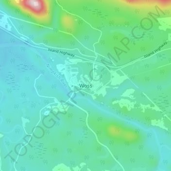
Name: Woss topographic map, elevation, terrain.
Average elevation: 201 m
Minimum elevation: 114 m
Maximum elevation: 614 m
Make a donation
Other topographic maps
Click on a map to view its topography, its elevation and its terrain.
Rice Lake
Canada > British Columbia > Regional District of Mount Waddington > Area D (Nimpkish Valley/Cormorant Island) > Woss
Average elevation: 234 m
Nimpkish Lake Provincial Park
Canada > British Columbia > Regional District of Mount Waddington > Area D (Nimpkish Valley/Cormorant Island)
Average elevation: 655 m
Newcastle Ridge
Canada > British Columbia > Regional District of Mount Waddington > Area D (Nimpkish Valley/Cormorant Island)
Average elevation: 1,047 m
Eve River
Canada > British Columbia > Regional District of Mount Waddington > Area D (Nimpkish Valley/Cormorant Island)
Average elevation: 571 m
Make a donation
Nimpkish Lake Provincial Park
Canada > British Columbia > Regional District of Mount Waddington > Area D (Nimpkish Valley/Cormorant Island)
Average elevation: 655 m