
Gloucester topographic map
Interactive map
Click on the map to display elevation.
About this map
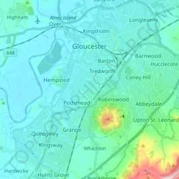
Name: Gloucester topographic map, elevation, terrain.
Location: Gloucester, Gloucestershire, Inglaterra, Reino Unido (51.80757 -2.30139 51.88522 -2.17726)
Average elevation: 36 m
Minimum elevation: 4 m
Maximum elevation: 274 m
Other topographic maps
Click on a map to view its topography, its elevation and its terrain.
Chargrove
Reino Unido > Inglaterra > Gloucestershire > Tewkesbury > Shurdington
Chargrove, Shurdington, Tewkesbury, Gloucestershire, Inglaterra, GL51 4XB, Reino Unido
Average elevation: 85 m
Cirencester
Reino Unido > Inglaterra > Gloucestershire > Cotswold > Chesterton
Cirencester, Chesterton, Cotswold, Gloucestershire, Inglaterra, Reino Unido
Average elevation: 128 m
Kempsford
Reino Unido > Inglaterra > Gloucestershire > Cotswold
Kempsford, Cotswold, Gloucestershire, Inglaterra, GL7 4EQ, Reino Unido
Average elevation: 78 m
Somerford Keynes
Reino Unido > Inglaterra > Gloucestershire > Cotswold
Somerford Keynes, Cotswold, Gloucestershire, Inglaterra, GL7 6DR, Reino Unido
Average elevation: 91 m
Poole Keynes
Reino Unido > Inglaterra > Gloucestershire > Cotswold
Poole Keynes, Cotswold, Gloucestershire, Inglaterra, GL7 6EG, Reino Unido
Average elevation: 99 m