
Make a donation
Nantucket topographic map
Click on the map to display elevation.
Make a donation
About this map
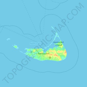
Name: Nantucket topographic map, elevation, terrain.
Location: Nantucket, Massachusetts, United States (41.18886 -70.39736 41.44339 -69.89364)
Average elevation: 1 m
Minimum elevation: -6 m
Maximum elevation: 28 m
Make a donation
Other topographic maps
Click on a map to view its topography, its elevation and its terrain.
Make a donation
Make a donation
Boston
United States > Massachusetts > Suffolk County > Boston
Boston has an area of 89.63 sq mi (232.1 km2)—48.4 sq mi (125.4 km2) (54%) of land and41.2 sq mi (106.7 km2) (46%) of water. The city's official elevation, as measured at Logan International Airport, is 19 ft (5.8 m) above sea level. The highest point in Boston is Bellevue Hill at 330 ft (100 m) above sea…
Average elevation: 26 m
Berkshire Heights
United States > Massachusetts > Berkshire County > Great Barrington
Average elevation: 243 m
Make a donation
Weymouth Woods
United States > Massachusetts > Norfolk County > Weymouth > South Weymouth > Pine Grove
Average elevation: 49 m
Make a donation
North Sunderland
United States > Massachusetts > Franklin County > Sunderland
Average elevation: 100 m
Make a donation
Make a donation
Freshwater Cove Village
United States > Massachusetts > Essex County > Gloucester
Average elevation: 18 m
Make a donation
Blackwater River
United States > Massachusetts > Essex County > Salisbury > Salisbury Beach
Average elevation: 4 m
North Chelmsford
United States > Massachusetts > Middlesex County > Chelmsford
Average elevation: 41 m
Make a donation
Eldon B. Kieth Field
United States > Massachusetts > Plymouth County > Brockton
Average elevation: 40 m
Make a donation
Make a donation
Marshfield Center
United States > Massachusetts > Plymouth County > Marshfield
Average elevation: 34 m
Mill Pond
United States > Massachusetts > Plymouth County > Duxbury > Miles Standish Park
Average elevation: 20 m
Make a donation
Crow Hill Ledges
United States > Massachusetts > Worcester County > Westminster
Average elevation: 293 m
Make a donation
South Hadley Falls
United States > Massachusetts > Hampshire County > South Hadley
Average elevation: 50 m
Little River Marshes
United States > Massachusetts > Essex County > Gloucester > West Gloucester
Average elevation: 27 m
Make a donation
Kenberma
United States > Massachusetts > Plymouth County > Hull > Nantasket Beach
Average elevation: 2 m
Make a donation
Make a donation
Hadwen Park
United States > Massachusetts > Worcester County > Worcester > Heard Street
Average elevation: 166 m
Make a donation
Make a donation
Make a donation
Mount Everett
United States > Massachusetts > Berkshire County
Mount Everett helps divide the watersheds of the Hudson and Housatonic rivers. Its eastern slopes share a larger escarpment with Mount Race and Bear Mountain plus several related summits. This escarpment rises from an elevation around 700 feet in Sheffield's Housatonic Valley at a mean angle of about 20…
Average elevation: 561 m
Make a donation
Hephzibah Heights
United States > Massachusetts > Berkshire County > Monterey
Average elevation: 457 m
Charles River Village
United States > Massachusetts > Norfolk County > Needham
Average elevation: 49 m
Make a donation
Northbridge Center
United States > Massachusetts > Worcester County > Northbridge
Average elevation: 124 m
Kettle Cove Village
United States > Massachusetts > Essex County > Manchester-by-the-Sea
Average elevation: 18 m
Make a donation
Medford Hillside
United States > Massachusetts > Middlesex County > Medford > West Medford
Average elevation: 13 m
Make a donation
Make a donation
Risingdale
United States > Massachusetts > Berkshire County > Great Barrington
Average elevation: 277 m
Make a donation
Brookside
United States > Massachusetts > Berkshire County > Great Barrington
Average elevation: 284 m
Make a donation