
okres Pezinok topographic map
Interactive map
Click on the map to display elevation.
About this map
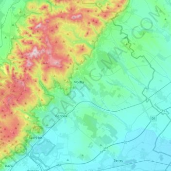
Name: okres Pezinok topographic map, elevation, terrain.
Location: okres Pezinok, Région de Bratislava, Slovaquie (48.20387 17.13422 48.45631 17.47752)
Average elevation: 262 m
Minimum elevation: 118 m
Maximum elevation: 746 m
Other topographic maps
Click on a map to view its topography, its elevation and its terrain.
Tatry
Slovaquie > Région de Bratislava > okres Pezinok
Tatry, okres Pezinok, Région de Bratislava, 900 91, Slovaquie
Average elevation: 422 m