
Préfecture autonome yi de Liangshan topographic map
Interactive map
Click on the map to display elevation.
About this map
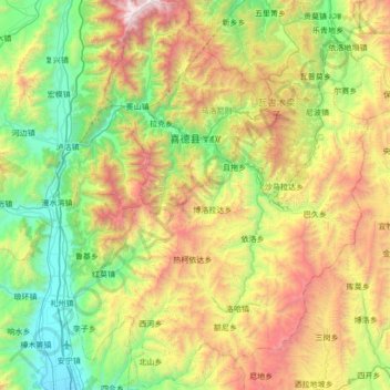
Name: Préfecture autonome yi de Liangshan topographic map, elevation, terrain.
Location: Préfecture autonome yi de Liangshan, 喜德县, Sichuan, Chine (27.88553 102.19179 28.52094 102.71462)
Average elevation: 2,460 m
Minimum elevation: 1,506 m
Maximum elevation: 4,423 m
Other topographic maps
Click on a map to view its topography, its elevation and its terrain.
古研
Chine > Sichuan > Préfecture autonome yi de Liangshan > 古研
古研, Préfecture autonome yi de Liangshan, Sichuan, Chine
Average elevation: 1,511 m