
Make a donation
Al Wakrah topographic map
Click on the map to display elevation.
Make a donation
Al Wakrah
Near Jebel Al Wakrah, the coastline's topography is characterized by the presence of relict coastal dunes composed of eolianite, a sedimentary rock formed by the lithification of wind-deposited sand. These geological formations, now manifesting as low-relief hills, date back to the Late Pleistocene epoch, coinciding with a period of lower eustatic sea levels.
Make a donation
About this map
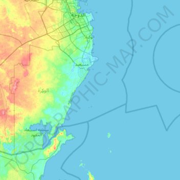
Name: Al Wakrah topographic map, elevation, terrain.
Location: Al Wakrah, Qatar (24.47482 51.08735 25.21982 52.23649)
Average elevation: 11 m
Minimum elevation: -2 m
Maximum elevation: 101 m
Make a donation
Other topographic maps
Click on a map to view its topography, its elevation and its terrain.
Al Rayyan
The city's name derives from the Arabic word ray, which translates to "irrigation". It was given this name due to its low elevation, allowing it to act as a flood plain during the rainy season and provide a prolonged supply of water to the numerous wild plants and crops that grew in the area.
Average elevation: 21 m
قرين أبو البول
Qurain Abu al-Bawl (also Gurain al Balbul, Gurain al Bâlbûl, Qurain Abul Bul, Qurayn Aba al Bawl, Qurayn Abā al Bawl, Tuwayyir al Hamir) is the highest point of Qatar, with an altitude of 103 metres (338 ft). It is located south of the peninsula near the border to Saudi Arabia.
Average elevation: 65 m
Al Ruwais
The area around Al Ruwais is generally characterized by a flat surface, lacking significant topographical complexities. This resembles much of the northern side of Qatar's coastal plain region, of which Al Ruwais is the northernmost extension. Between Al Jumail and Al Ruwais, the coastline features several…
Average elevation: 5 m
Make a donation
Lusail
Groundwater quality in the area is poor. On the city's border with the Persian Gulf, the groundwater elevation is 1 meter above sea level and flows east-to-west. Salinity levels are highest on the eastern side, at 40 ppt, compared to a low of 18 ppt in the western section; these levels are too high for…
Average elevation: 9 m
Make a donation
Al Rayyan
The city's name derives from the Arabic word "ray", which translates to "irrigation". It was given this name due to its low elevation, allowing it to act as a flood plain during the rainy season and provide a prolonged supply of water to the numerous wild plants and crops that grew in the area.
Average elevation: 21 m
Make a donation
Lusail
Groundwater quality in the area is poor. On the city's border with the Persian Gulf, the groundwater elevation is 1 meter above sea level and flows east-to-west. Salinity levels are highest on the eastern side, at 40 ppt, compared to a low of 18 ppt in the western section; these levels are too high for…
Average elevation: 9 m