
Douglas County topographic map
Interactive map
Click on the map to display elevation.
About this map
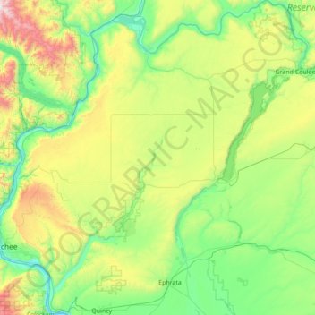
Name: Douglas County topographic map, elevation, terrain.
Location: Douglas County, Washington, United States of America (47.22005 -120.31808 48.15019 -118.95272)
Average elevation: 634 m
Minimum elevation: 171 m
Maximum elevation: 2,318 m
Other topographic maps
Click on a map to view its topography, its elevation and its terrain.
Spokane County
United States of America > Washington
Spokane County, Washington, United States of America
Average elevation: 741 m
Yakima County
United States of America > Washington
Yakima County, Washington, United States of America
Average elevation: 879 m
Thurston County
United States of America > Washington
Thurston County, Washington, United States of America
Average elevation: 150 m
Okanogan County
United States of America > Washington > Okanogan County
Okanogan County, Washington, United States of America
Average elevation: 1,076 m
Snohomish County
United States of America > Washington
Snohomish County, Washington, United States of America
Average elevation: 649 m