
Preble County topographic map
Interactive map
Click on the map to display elevation.
About this map
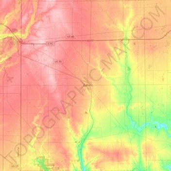
Name: Preble County topographic map, elevation, terrain.
Location: Preble County, Ohio, United States (39.56729 -84.81514 39.91842 -84.47878)
Average elevation: 315 m
Minimum elevation: 227 m
Maximum elevation: 376 m
Other topographic maps
Click on a map to view its topography, its elevation and its terrain.
Blue Rock
United States > Ohio > Muskingum County
Blue Rock, Muskingum County, Ohio, 43720, United States
Average elevation: 253 m
Findlay
United States > Ohio > Findlay
Findlay, Hancock County, Ohio, United States
Average elevation: 243 m