
Make a donation
Lake Michigan topographic map
Click on the map to display elevation.
Make a donation
Lake Michigan
Lake Michigan is one of the five Great Lakes of North America. It is the second-largest of the Great Lakes by volume (1,180 cu mi (4,900 km3)) and the third-largest by surface area (22,404 sq mi (58,030 km2)), after Lake Superior and Lake Huron. To the east, its basin is conjoined with that of Lake Huron through the 3+1⁄2 miles (5.6 kilometers) wide, 295 feet (90 meters; 49 fathoms) deep, Straits of Mackinac, giving it the same surface elevation as its easterly counterpart; the two are technically a single lake.
Make a donation
About this map
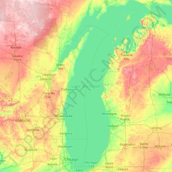
Name: Lake Michigan topographic map, elevation, terrain.
Location: Lake Michigan, United States (41.60887 -88.04169 46.10229 -84.75193)
Average elevation: 260 m
Minimum elevation: 169 m
Maximum elevation: 582 m
Make a donation
Other topographic maps
Click on a map to view its topography, its elevation and its terrain.
Fort Benning
United States > Georgia > Chattahoochee County > Chattahoochee County
Average elevation: 95 m
Flagstaff
United States > Arizona > Coconino County
Flagstaff, located in Coconino County, Arizona, is characterized by its diverse topography, primarily shaped by its high elevation and volcanic activity. Sitting at around 7,000 feet (approximately 2,130 meters), the city is surrounded by the expansive Coconino National Forest, which features a blend of…
Average elevation: 2,176 m
Baltimore
Baltimore exhibits a diverse topography that plays a significant role in its character and development. Situated along the Patapsco River, which flows into the Chesapeake Bay, the city is positioned on the fall line that separates the Piedmont Plateau to the west from the Atlantic Coastal Plain to the east.…
Average elevation: 65 m
Augusta
United States > Georgia > Augusta
As with the rest of the state, Augusta has a humid subtropical climate (Köppen Cfa), with short, mild winters, very hot, humid summers, and a wide diurnal temperature variation throughout much of the year, despite its low elevation and moisture. The monthly daily average temperature ranges from 45.4 °F (7.4…
Average elevation: 90 m
Make a donation
Fairbanks
United States > Alaska > Fairbanks North Star
Fairbanks is situated within the central Tanana Valley, characterized by a diverse and dynamic topography. The city straddles the Chena River, which flows southwest into the larger Tanana River, defining Fairbanks' southern border. To the north, a gradual incline leads into a chain of hills that ascend toward…
Average elevation: 146 m
Madison
United States > Wisconsin > Dane County
The city is sometimes described as The City of Four Lakes, comprising the four successive lakes of the Yahara River: Lake Mendota ("Fourth Lake"), Lake Monona ("Third Lake"), Lake Waubesa ("Second Lake") and Lake Kegonsa ("First Lake"), although Waubesa and Kegonsa are not actually in Madison, but just south…
Average elevation: 289 m
Make a donation
Atlanta
United States > Georgia > Fulton County
Atlanta (/ætˈlæntə/ at-LAN-tə) is the capital and most populous city of the U.S. state of Georgia. It is the seat of Fulton County, the most populous county in Georgia. With a population of 498,715 living within the city limits, it is the eighth most populous city in the Southeast and 38th most populous…
Average elevation: 285 m
Virginia Beach
United States > Virginia > Virginia Beach
Virginia Beach, Virginia, located in the coastal region of the United States, features a predominantly flat terrain characterized by its proximity to the Atlantic Ocean. The elevation is remarkably low, averaging about 10 feet (3 meters) above sea level, which contributes to the area's susceptibility to…
Average elevation: 2 m
Sebastopol
United States > California > Sonoma County
Sebastopol's elevation is 65 to 250 feet (20 to 76 meters) above sea level. Its downtown is at the intersection of State Route 12 and State Route 116 (Gravenstein Highway), approximately 9 mi (14 km) west of U.S. Route 101.
Average elevation: 69 m
Make a donation
Lancaster
United States > California > Lancaster
According to the United States Census Bureau, the city has a total area of 94.5 square miles (245 km2), of which 94.3 square miles (244 km2) is land and 0.3 square miles (0.78 km2) (0.29%) is water. Lancaster's elevation is 2,350 feet (720 m) above sea level on a high, flat valley surrounded by pristine…
Average elevation: 787 m
Indianapolis
United States > Indiana > Indianapolis
Indianapolis is within the Tipton Till Plain, a flat to gently sloping terrain underlain by glacial deposits known as till. The lowest point in the city is about 650 feet (198 m) above mean sea level, with the highest natural elevation at about 900 feet (274 m) above sea level. Few hills or short ridges, known…
Average elevation: 241 m
Tucson
United States > Arizona > Pima County > Tucson
The city's elevation is 2,643 ft (806 m) above sea level (as measured at the Tucson International Airport). Tucson is on an alluvial plain in the Sonoran Desert, surrounded by five minor ranges of mountains: the Santa Catalina Mountains and the Tortolita Mountains to the north, the Santa Rita Mountains to the…
Average elevation: 836 m
Make a donation
Make a donation
Hot Springs National Park
United States > Arkansas > Garland County > Hot Springs
The National Park Service exercises no control or supervision over any matters connected with the city. The city starts on the other side of Central Avenue from Bathhouse Row. Its development has extended beyond the narrow valley in which the springs are located, spreading out over the open plain to the south…
Average elevation: 227 m
Snoqualmie Pass
United States > Washington > King County
Due to its elevation, Snoqualmie Pass experiences significantly lower temperatures than Seattle, and receives much more precipitation, much of it being snow. Snoqualmie Pass has a humid continental climate (Koppen: Dsb bordering Csb) with cold, very wet and snowy winters, and mild to warm, relatively dry…
Average elevation: 1,048 m
Make a donation
East Hampton
United States > New York > Suffolk County > East Hampton > Village of East Hampton
Average elevation: 12 m
Thousand Oaks
United States > California > Ventura County > Thousand Oaks
The northern parts consist of mountainous terrain in the Simi Hills, Conejo Mountains and Mount Clef Ridge. Narrow canyons such as Hill Canyon cut through the steeper mountainous areas. Conejo Mountain and Conejo Grade are found in westernmost Newbury Park, while the southernmost parts of Thousand Oaks are…
Average elevation: 303 m
Winnemucca
United States > Nevada > Humboldt County > Winnemucca > Winnemucca
Average elevation: 1,403 m
Make a donation
Elizabethton
United States > Tennessee > Carter County > Elizabethton > Elizabethton
The elevation at Elizabethton Municipal Airport is 1,593 feet (486 m) ASL (the highest point of elevation in Carter County is at Roan Mountain with an elevation of 6,285 feet (1,916 m) ASL), and the airport is located on the eastern side of the city along State Highway 91 Stoney Creek Exit. Elizabethton is…
Average elevation: 527 m
Bozeman
United States > Montana > Gallatin County
Bozeman is located at an elevation of 4,820 feet (1,470 m). The Bridger Mountains are to the north-northeast, the Tobacco Root Mountains to the west-southwest, the Big Belt Mountains and Horseshoe Hills to the northwest, the Hyalite Peaks of the northern Gallatin Range to the south and the Spanish Peaks of the…
Average elevation: 1,679 m
Wake Island
On November 1, 2015, a complex $230 million U.S. military missile defense system test event, called Campaign Fierce Sentry Flight Test Operational-02 Event 2 (FTO-02 E2), was conducted at Wake Island and the surrounding ocean areas. The test involved a Terminal High Altitude Area Defense (THAAD) system built…
Average elevation: 1 m
Make a donation
Tombstone
United States > Arizona > Tombstone > Tombstone
The Tombstone District located at 31°42′57″N 110°3′53″W / 31.71583°N 110.06472°W / 31.71583; -110.06472 (31.715940, −110.064827) sits atop a mesa (elevation 4,539 feet (1,383 m)) in the San Pedro River valley between the Huachuca Mountains and Whetstone Mountains to the west, and the…
Average elevation: 1,362 m
Menifee
United States > California > Riverside County
Menifee is a city in Riverside County, California, United States, and part of the Los Angeles Combined Statistical Area. The city is centrally located in Southern California in the Menifee Valley. It is almost 15 miles (24 km) north of Temecula and just north of Murrieta. Menifee is roughly 46 square miles…
Average elevation: 456 m
Make a donation
Monte Sano Mountain
United States > Alabama > Madison County
The top is relatively flat and lies just under 500 meters above sea level. This elevation is about 300 meters higher than the floor of the Tennessee Valley, which surrounds it. A residential neighborhood occupies the western portion of the top. The eastern portion and slopes of the mountain are occupied by…
Average elevation: 396 m
Make a donation
Make a donation
Crater of Diamonds State Park
United States > Arkansas > Pike County > Murfreesboro > Kimberley
Average elevation: 106 m
Make a donation
Air Force Academy
United States > Colorado > El Paso County > Colorado Springs
The campus of the academy covers 18,455 acres (29 sq mi; 75 km2) on the east side of the Rampart Range of the Rocky Mountains, just north of Colorado Springs. Its elevation is normally given as 7,258 feet (2,212 m) above sea level, which is at the cadet area. The academy was designed by Skidmore, Owings and…
Average elevation: 2,158 m
Austin
United States > Texas > Travis County
The elevation of Austin varies from 425 feet (130 m) to approximately 1,000 feet (305 m) above sea level. Due to the fact it straddles the Balcones Fault, much of the eastern part of the city is flat, with heavy clay and loam soils, whereas the western part and western suburbs consist of rolling hills on the…
Average elevation: 203 m
Make a donation
Exton
United States > Pennsylvania > Chester County > West Whiteland Township
Average elevation: 125 m
Twentynine Palms
United States > California > Twentynine Palms
According to the United States Census Bureau, the city has a total area of 59.1 square miles (153 km2), all land. The city is at an elevation of 1,988 feet (606 m). The Marine Corps Air Ground Combat Center Twentynine Palms is located there.
Average elevation: 690 m
Make a donation
Make a donation
Watertown
United States > New York > Jefferson County
Watertown is around 60 miles (97 kilometers) northwest of Syracuse, 20 miles (32 kilometers) south of the Thousand Islands and 328 miles (530 kilometers) northwest of New York City. According to the United States Census Bureau, the city has a total area of 9.3 square miles (24 km2), of which 9.0 square miles…
Average elevation: 196 m
Make a donation
Dallas
United States > Texas > Dallas County
Dallas and its surrounding area are mostly flat. The city lies at elevations ranging from 450 to 550 feet (137 to 168 m) above sea level. The western edge of the Austin Chalk Formation, a limestone escarpment (also known as the "White Rock Escarpment"), rises 230 feet (70 m) and runs roughly north–south…
Average elevation: 158 m
Diamondhead
United States > Mississippi > Hancock County
Much of the land that became Diamondhead had been purchased by Walter Gex, Sr., in 1937 from the Gulf State Paper Company and the Easy Opener Bag Company. Additional land was purchased by Gex, bringing his acquisition to nearly 5,000 acres (2,000 ha). In the late 1960s, D.E.A.R., Inc., later known as the…
Average elevation: 3 m
Make a donation
Seligman
United States > Arizona > Yavapai County > Seligman
Seligman is located at 35°19′42″N 112°52′27″W / 35.32833°N 112.87417°W / 35.32833; -112.87417 (35.328199, −112.874303), at 5,240 feet (1,600 m) in elevation, alongside the Big Chino Wash, in a northern section of Chino Valley. The wash is a major tributary of the Verde River. Seligman is…
Average elevation: 1,617 m
Marfa
United States > Texas > Presidio County
Marfa is a city in the high desert of the Trans-Pecos in far West Texas, United States, between the Davis Mountains and Big Bend National Park, at an elevation of 4685 feet. It is the county seat of Presidio County, and its population as of the 2020 United States Census was 1,788. The city was founded in the…
Average elevation: 1,434 m
Kearny
United States > Arizona > Pinal County
Kearny Airport is a general aviation airport located in the southern section of the town. In 2003 it received the Arizona Department of Transportation's Airport of the Year award. The airport has a single asphalt runway, 3,400 feet (1,000 m) in length and 60 feet (18 m) in width, with a field elevation of…
Average elevation: 578 m
Make a donation
Mississippi
Mississippi is entirely composed of lowlands, the highest point being Woodall Mountain, at 807 ft (246 m) above sea level, in the northeastern part of the state. The lowest point is sea level at the Gulf Coast. The state's mean elevation is 300 ft (91 m) above sea level.
Average elevation: 87 m
Make a donation
Make a donation
Make a donation
Eureka Springs
United States > Arkansas > Carroll County > Eureka Springs
It is a tourist destination for its unique character as a Victorian resort village. The city has steep winding streets filled with Victorian-style cottages and manors. The historic commercial downtown of the city has an extensive streetscape of well-preserved Victorian buildings. The buildings are primarily…
Average elevation: 417 m
Make a donation
Alfred
United States > New York > Allegany County > Alfred
The elevation of Alfred is about 1,700 feet (520 m) but rises to a high point of 2,355 feet (718 m) at the summit of Jericho Hill just south of the village. The hills greatly affect the weather in the region, which results in quick changes as well as different conditions in neighboring valleys.
Average elevation: 604 m
Make a donation
Make a donation
Make a donation