
Kaltenbach topographic map
Interactive map
Click on the map to display elevation.
About this map
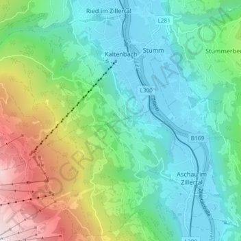
Name: Kaltenbach topographic map, elevation, terrain.
Location: Kaltenbach, Bezirk Schwaz, 6272, Oostenrijk (47.25502 11.81122 47.29905 11.88449)
Average elevation: 982 m
Minimum elevation: 549 m
Maximum elevation: 2,135 m
Other topographic maps
Click on a map to view its topography, its elevation and its terrain.
Ried im Zillertal
Ried im Zillertal, Bezirk Schwaz, 6273, Oostenrijk
Average elevation: 1,038 m
Gerlosberg
Oostenrijk > Bezirk Schwaz > Gerlosberg
Gerlosberg, Bezirk Schwaz, 6280, Oostenrijk
Average elevation: 1,220 m