
Ried im Zillertal topographic map
Interactive map
Click on the map to display elevation.
About this map
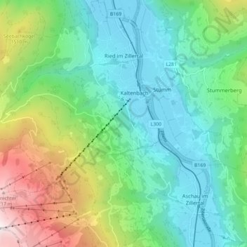
Name: Ried im Zillertal topographic map, elevation, terrain.
Location: Ried im Zillertal, Bezirk Schwaz, 6273, Oostenrijk (47.25371 11.80225 47.31302 11.87619)
Average elevation: 1,038 m
Minimum elevation: 540 m
Maximum elevation: 2,324 m
Other topographic maps
Click on a map to view its topography, its elevation and its terrain.
Kaltenbach
Kaltenbach, Bezirk Schwaz, 6272, Oostenrijk
Average elevation: 982 m
Gerlosberg
Oostenrijk > Bezirk Schwaz > Gerlosberg
Gerlosberg, Bezirk Schwaz, 6280, Oostenrijk
Average elevation: 1,220 m