
La Unión topographic map
Interactive map
Click on the map to display elevation.
About this map
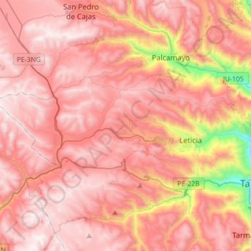
Name: La Unión topographic map, elevation, terrain.
Location: La Unión, Province of Tarma, Junín, Peru (-11.40318 -75.96019 -11.32149 -75.70734)
Average elevation: 4,036 m
Minimum elevation: 3,007 m
Maximum elevation: 4,522 m
Other topographic maps
Click on a map to view its topography, its elevation and its terrain.
Barrio Independencia
Barrio Independencia, San José de Quero, Province of Concepción, Junín, Peru
Average elevation: 3,987 m
Chanchamayo
Peru > Junín > Santo Domingo de Acobamba > Chanchamayo
Chanchamayo, Santo Domingo de Acobamba, Province of Huancayo, Junín, Peru
Average elevation: 2,582 m
Carhuamayo
Peru > Junín > Carhuamayo
Carhuamayo, Province of Junín, Junín, Peru
Average elevation: 4,248 m