
Province of Tarma topographic map
Interactive map
Click on the map to display elevation.
About this map
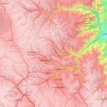
Name: Province of Tarma topographic map, elevation, terrain.
Location: Province of Tarma, Junín, 12651, Peru (-11.60114 -75.97208 -10.90030 -75.40195)
Average elevation: 3,783 m
Minimum elevation: 854 m
Maximum elevation: 5,014 m
Other topographic maps
Click on a map to view its topography, its elevation and its terrain.
Barrio Independencia
Barrio Independencia, San José de Quero, Province of Concepción, Junín, Peru
Average elevation: 3,987 m
Chanchamayo
Peru > Junín > Santo Domingo de Acobamba > Chanchamayo
Chanchamayo, Santo Domingo de Acobamba, Province of Huancayo, Junín, Peru
Average elevation: 2,582 m
Carhuamayo
Peru > Junín > Carhuamayo
Carhuamayo, Province of Junín, Junín, Peru
Average elevation: 4,248 m