
Make a donation
St. Gallen topographic map
Click on the map to display elevation.
Make a donation
St. Gallen
The main rivers of the canton are the Rhine, Thur, Linth and Seez. The topography changes from the plains, near river Rhine and Lake Constance, towards the mountainous areas of the Alps in the south (Appenzell Alps and Glarus Alps). About one third (619.7 square kilometers (239.3 sq mi)) of the canton is wooded, while nearly half is 9,790.6 km2 (3,780.2 sq mi) is used for farming. 278.6 km2 (107.6 sq mi) of the farm land is alpine pastures. Of the rest of the canton, 259.1 km2 (100.0 sq mi) is considered unproductive while 176 km2 (68 sq mi) is filled with housing or roads.
Make a donation
About this map
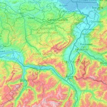
Name: St. Gallen topographic map, elevation, terrain.
Location: St. Gallen, Switzerland (46.87289 8.79561 47.54721 9.67414)
Average elevation: 1,070 m
Minimum elevation: 392 m
Maximum elevation: 3,162 m
Make a donation
Other topographic maps
Click on a map to view its topography, its elevation and its terrain.
Make a donation
Sankt Stephan
Switzerland > Bern > Obersimmental-Saanen administrative district > St. Stephan
Average elevation: 1,310 m
Brienz
Switzerland > Bern > Interlaken-Oberhasli administrative district > Brienz (BE)
Average elevation: 810 m
Make a donation
Gimmelwald
Switzerland > Bern > Interlaken-Oberhasli administrative district
Average elevation: 1,564 m
Make a donation
Oeschinen Lake
Switzerland > Bern > Frutigen-Niedersimmental administrative district > Kandersteg
Oeschinen Lake (German: Oeschinensee) is a lake in the Bernese Oberland, Switzerland, 4 kilometres (2.5 mi) east of Kandersteg in the Oeschinen valley. At an elevation of 1,578 metres (5,177 ft), it has a surface area of 1.1147 square kilometres (0.4304 sq mi). Its maximum depth is 56 metres (184 ft).
Average elevation: 1,918 m
Jungfrau
Switzerland > Bern > Interlaken-Oberhasli administrative district > Lauterbrunnen
The difference of altitude between the deep valley of Lauterbrunnen (800 m or 2,600 ft) and the summit is particularly visible from the area of Mürren. From the valley floor, west of the massif, the altitude gain is more than 3 km (1.9 mi) for a horizontal distance of 4 km (2.5 mi).
Average elevation: 3,401 m
Make a donation
Lausanne
Switzerland > Vaud > District de Lausanne > Lausanne
The most important geographical feature of the area surrounding Lausanne is Lake Geneva (Lac Léman in French). Lausanne is built on the southern slope of the Swiss plateau, with a difference in elevation of about 500 metres (1,640 ft) between the lakeshore at Ouchy and its northern edge bordering Le…
Average elevation: 577 m
Make a donation
Schilthorn
Switzerland > Bern > Interlaken-Oberhasli administrative district > Lauterbrunnen
Average elevation: 2,455 m
Hasliberg Wasserwendi
Switzerland > Bern > Interlaken-Oberhasli administrative district
Average elevation: 1,247 m
Make a donation
Chironico
Switzerland > Ticino > Distretto di Leventina
The municipality is located in the Leventina district, on the right slope of the mid-Leventina valley at an elevation of 786 meters (2,579 ft). The municipality stretches from the Ticino river at the Biaschina-Schlucht (elevation 450 m (1,480 ft)) up to the Pizzo Campo Tencia (3,072 m (10,079 ft)) in the upper…
Average elevation: 1,026 m
Make a donation
Make a donation
Furi
Switzerland > Wallis > Visp > Zermatt
Furi is an alpine hamlet in the Pennine Alps, located three kilometers south of Zermatt, Switzerland at an altitude of 1,687m. It is located on a relatively flat area of land between the Gornera and Zmuttbach rivers.
Average elevation: 2,206 m
Combe du Bez
Switzerland > Bern > Bernese Jura administrative district > Corgémont
Average elevation: 1,037 m
Make a donation
Gimmelwald
Switzerland > Bern > Interlaken-Oberhasli administrative district
Average elevation: 1,564 m
S. Antonio (Val Morobbia)
Switzerland > Ticino > Distretto di Bellinzona > Bellinzona
Average elevation: 1,004 m
Make a donation
Oberwald
Switzerland > Wallis > Goms > Obergoms
It is situated at an elevation of 1,377 m and had a population of 277 in December 2007. It is located at the end of the Goms, directly before the Furka and Grimsel passes, underneath the Rhône River source at the Rhône Glacier. It is also the startpoint of the Furka Tunnel and is served by Oberwald railway…
Average elevation: 1,744 m
Make a donation
Eiger
Switzerland > Bern > Interlaken-Oberhasli administrative district > Grindelwald
Average elevation: 2,944 m
Make a donation
Make a donation
Make a donation
Gstaad
Switzerland > Bern > Obersimmental-Saanen administrative district
Long known for its walking and hiking trails of varying degrees of difficulty, the mountain air and ambiance attract guests year-round from around the world. Gstaad is also known for its ski and cross-country slopes and winter hiking trails. Glacier 3000 is a major attraction, offering guaranteed snow from…
Average elevation: 1,245 m
Make a donation
Les Avants
Switzerland > Vaud > District de la Riviera-Pays-d’Enhaut > Montreux
Average elevation: 1,111 m
Monte Rosa
Switzerland > Wallis > Visp > Zermatt
The peak is distinguished by the name Dufourspitze (in German, lit. Dufour Peak; French: Pointe Dufour, Italian: Punta Dufour). This replaced the former name Höchste Spitze (English: Highest Peak) that was indicated on the Swiss maps before the Federal Council, on January 28, 1863, decided to rename the…
Average elevation: 4,033 m
Make a donation
Jungfrau
Switzerland > Bern > Interlaken-Oberhasli administrative district > Lauterbrunnen
The difference of altitude between the deep valley of Lauterbrunnen (800 m or 2,600 ft) and the summit is particularly visible from the area of Mürren. From the valley floor, west of the massif, the altitude gain is more than 3 km (1.9 mi) for a horizontal distance of 4 km (2.5 mi).
Average elevation: 3,401 m
Albulapass
Switzerland > Grisons > Maloja > La Punt Chamues-ch
The Albula Pass is an important axis from central Graubünden to Engadin. It is traversed by a paved road from Thusis to La Punt, via Bergün. It is also traversed by the Albula Railway, although at a lower elevation through the Albula Tunnel (1,820 m), from Thusis to Bever, also via Bergün.
Average elevation: 2,560 m
Gimmelwald
Switzerland > Bern > Interlaken-Oberhasli administrative district
Average elevation: 1,564 m
Make a donation
Make a donation
Piz Linard
Switzerland > Grisons > Region Engiadina Bassa/Val Müstair > Zernez
Average elevation: 2,626 m
Schwarzhoren
Switzerland > Bern > Interlaken-Oberhasli administrative district > Grindelwald
Average elevation: 2,468 m
Make a donation
Berninapass
Switzerland > Grisons > Maloja > Pontresina
The building of the road began in 1842. Head of engineers was Rudolf Albertini (1821–1896) from Zuoz. The work was finished in 1865 and a hospice at an elevation of 2,307 metres (7,569 ft) was also opened. Since this time the road has been widened several times. Since 1965 it has been open all year round,…
Average elevation: 2,351 m
Mase
Switzerland > Wallis > Hérens > Mont-Noble
The village is located in the Hérens district on the right bank of the Borgne and the left bank of the Rhone in the Val d'Hérens at an elevation of 1,345 m (4,413 ft). It consists of the village of Mase.
Average elevation: 1,272 m
Make a donation
Make a donation
Männlichen
Switzerland > Bern > Interlaken-Oberhasli administrative district > Grindelwald
Average elevation: 1,709 m
Make a donation
Make a donation
Bodio TI
Switzerland > Ticino > Distretto di Leventina
The municipality is located in the Leventina district, at an elevation of 321 m (1,053 ft) on the left side of the lower Leventina valley.
Average elevation: 875 m
Make a donation
Murris
Switzerland > St. Gallen > Wahlkreis Werdenberg > Wartau > Weite-Wartau
Average elevation: 550 m
Make a donation