
Fernisky topographic map
Interactive map
Click on the map to display elevation.
About this map
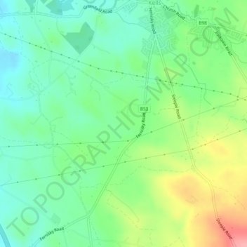
Name: Fernisky topographic map, elevation, terrain.
Location: Fernisky, Kells, County Antrim, Irlande du Nord, Royaume-Uni (54.78817 -6.24353 54.80222 -6.21151)
Average elevation: 89 m
Minimum elevation: 53 m
Maximum elevation: 157 m
Other topographic maps
Click on a map to view its topography, its elevation and its terrain.
Cullycapple
Royaume-Uni > Irlande du Nord > Kells
Cullycapple, Kells, County Antrim, Irlande du Nord, BT41 2LD, Royaume-Uni
Average elevation: 62 m
Gallanagh
Royaume-Uni > Irlande du Nord > Kells
Gallanagh, Kells, County Antrim, Irlande du Nord, Royaume-Uni
Average elevation: 118 m