
Cullycapple topographic map
Interactive map
Click on the map to display elevation.
About this map
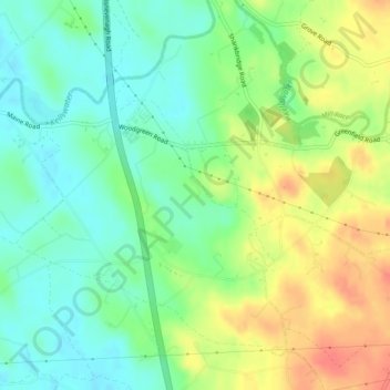
Name: Cullycapple topographic map, elevation, terrain.
Average elevation: 62 m
Minimum elevation: 40 m
Maximum elevation: 93 m
Other topographic maps
Click on a map to view its topography, its elevation and its terrain.
Gallanagh
Royaume-Uni > Irlande du Nord > Kells
Gallanagh, Kells, County Antrim, Irlande du Nord, Royaume-Uni
Average elevation: 118 m
Fernisky
Royaume-Uni > Irlande du Nord > Kells
Fernisky, Kells, County Antrim, Irlande du Nord, Royaume-Uni
Average elevation: 89 m