
Make a donation
Black Mountain topographic map
Click on the map to display elevation.
Make a donation
Black Mountain
Black Mountain is the highest mountain peak in the Commonwealth of Kentucky, United States, with a summit elevation of 4,145 feet (1,263 m) above mean sea level and a top-to-bottom height of over 2,500 feet (760 m). The summit is located at approximately 36°54′51″N 82°53′38″W / 36.91417°N 82.89389°W / 36.91417; -82.89389 in Harlan County, Kentucky near the Virginia border, just above the towns of Lynch, Kentucky and Appalachia, Virginia. It is alternatively known as Katahrin's Mountain, and is about 500 feet (150 m) taller than any other mountain in Kentucky.
Make a donation
About this map
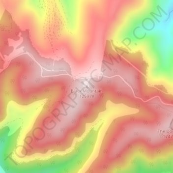
Name: Black Mountain topographic map, elevation, terrain.
Location: Black Mountain, Harlan County, Kentucky, United States (36.91428 -82.89391 36.91438 -82.89381)
Average elevation: 1,108 m
Minimum elevation: 810 m
Maximum elevation: 1,253 m
Make a donation
Other topographic maps
Click on a map to view its topography, its elevation and its terrain.
Louisville
United States > Kentucky > Jefferson County
Louisville features a diverse topography shaped by the Ohio River and surrounding landscape. The city lies at an elevation of approximately 466 feet (142 meters) and is characterized by rolling hills and valleys, with the highest point in the county reaching about 902 feet (275 meters) at South Park Hill in…
Average elevation: 188 m
Jefferson County
The highest point is South Park Hill, elevation 902 feet (275 m), located in the southern part of the county. The lowest point is 383 feet (117 m) along the Ohio River just north of West Point.
Average elevation: 184 m
Make a donation
Mockingbird Valley
United States > Kentucky > Jefferson County
Numerous wild animals reside in Mockingbird Valley, including white-tailed deer, coyote, red fox, groundhog, opossum, raccoon and the occasional mink. Birding enthusiasts have also recorded sightings of wild turkey, blue heron, turkey vulture, red tail hawk, pileated woodpecker, and the great horned owl. Due…
Average elevation: 159 m
Somerset
United States > Kentucky > Pulaski County
Somerset is located at 37°4′59″N 84°36′34″W / 37.08306°N 84.60944°W / 37.08306; -84.60944 (37.082966, −84.609387), and the downtown (central) part of the city is at an elevation of 974 feet above sea level. The city is located at the eastern end of Kentucky's Mississippian Plateau (or…
Average elevation: 295 m
Make a donation
Whitley County
Whitley County is located within the Cumberland Plateau of southeastern Kentucky, which is greatly overlapped by the broad Eastern Coal Field region of the state. Because of its location in the midst of Cumberland Mountains, elevations in the county range from 723 to 2,220 feet (220 to 677 m) above sea level.…
Average elevation: 368 m
Make a donation
Letcher County
The county's terrain is defined by rugged mountains and blanketed by forests. Jefferson National Forest covers a significant portion of the county. The county's highest point is Black Mountain, located in the southeastern corner of the county, with an elevation of 3,700 feet.
Average elevation: 575 m
Make a donation
Make a donation
Harlan County
Black Mountain, located east of Lynch, is Kentucky's highest point, with an elevation of 4,145 feet (1,263 m) above sea level.
Average elevation: 560 m
Johnson County
The county's highest point is Stuffley Knob, with an elevation of 1,496 feet (456 m). Its lowest point is the Levisa Fork on the Lawrence County border, with an elevation of about 550 feet (170 m).
Average elevation: 279 m
Make a donation
Lewis County
The county's elevation ranges from 485 to 1400 feet above sea level. Its heavily forested hills and hollows have produced some of the nation's best oak lumber. Lumbering was long the county's principal economic activity; today the largest categories of employment are health care and social assistance (814…
Average elevation: 275 m
Make a donation
Make a donation
Owsley County
The county is located in the Eastern Mountain Coal Fields which is a part of the Appalachian Plateau (more precisely, the Cumberland Plateau). The elevation of the highest summit in the county is 1,730 ft (530 m) (+/- 10 ft (3 m)). It is located on the county's extreme southern boundary with Clay County. The…
Average elevation: 321 m
Estill County
Estill County contains two important rivers. With the Red River, famous for its gorge in neighboring Powell County, forming the northern border. And the Kentucky River bisecting the county. Much of Estill County's development, including the towns of Irvine and Ravenna, is located in the fertile bottomlands of…
Average elevation: 283 m
Make a donation
Jackson County
One fourth of Jackson County is within the Daniel Boone National Forest (56,000 acres), making it representative of eastern Kentucky's unique Appalachian topography, wildlife, and heritage. The county is home to many attractions and recreation spots such as Flat Lick Falls, public national forest campgrounds…
Average elevation: 358 m
Make a donation
Make a donation
Make a donation
Wayne County
The county's elevation ranges from 656 to 1,870 feet (200 to 570 m) ASL, at the Monticello/Wayne County Airport the elevation is 963 feet (294 m). Wayne County is located in the Pennyrile Plateau (image) Archived October 9, 2004, at the Wayback Machine and Eastern Coal Field (image) Archived October 9, 2004,…
Average elevation: 323 m
Make a donation
Jefferson County
The highest point is South Park Hill, elevation 902 feet (275 m), located in the southern part of the county. The lowest point is 383 feet (117 m) along the Ohio River just north of West Point.
Average elevation: 184 m
Make a donation
Louisville
United States > Kentucky > Jefferson County
Throughout January 1937, 19.17 inches (48.7 cm) of rain fell in Louisville, and by January 27, the Ohio River crested at a record 57.15 feet (17.42 m), almost 30 feet (9.1 m) above flood stage. These events triggered the "Great Flood of 1937", which lasted into early February. The flood submerged 60–70…
Average elevation: 188 m
Meade County
Much of the county has the presence of sinkholes as the area's topography is primarily karst plains with occasional hills and elevations rising above. Northwest Meade County is mainly situated on a plateau, separated from karst plains by the Dripping Springs Escarpment, an easterly-facing cuesta.
Average elevation: 199 m
Make a donation
Make a donation
Make a donation
Kenton County
According to the United States Census Bureau, the county has a total area of 164 square miles (420 km2), of which 160 square miles (410 km2) is land and 4.1 square miles (11 km2) (2.5%) is water. The county is located at the confluence of the Licking River and Ohio River, in the outer Bluegrass area of the…
Average elevation: 233 m
Make a donation
Make a donation
Westwood
United States > Kentucky > Boyd County > Fairview
Westwood is a census-designated place in Boyd County, Kentucky, United States. The population was 4,387 at the 2020 census. A suburb of Ashland, the two areas are closely affiliated, sharing a ZIP code and bus system. Westwood is located on a flat to hilly elevation just west of the Ohio River. The flat…
Average elevation: 192 m
Make a donation
Make a donation
Make a donation
E.P. "Tom" Sawyer State Park
United States > Kentucky > Jefferson County > Louisville > Lakeland
Average elevation: 209 m
Make a donation
Make a donation
Make a donation