
Make a donation
Malvern Hill topographic map
Click on the map to display elevation.
Make a donation
About this map
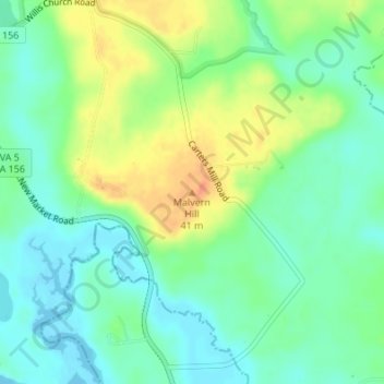
Name: Malvern Hill topographic map, elevation, terrain.
Location: Malvern Hill, Henrico County, Virginia, United States (37.39704 -77.24030 37.39714 -77.24020)
Average elevation: 17 m
Minimum elevation: 0 m
Maximum elevation: 45 m
Make a donation
Other topographic maps
Click on a map to view its topography, its elevation and its terrain.
Carroll County
The first European settlers arrived in the region in the mid 18th century. These were primarily Scotch-Irish pioneers, who were used to high mountain altitudes. However, early settlement was slow, mostly due to the poor agricultural soil of the area. As a result, lead mining was one of the first economic…
Average elevation: 709 m
Blue Ridge
United States > Virginia > Loudoun County
Blue Ridge Mountain is noticeably lower in elevation than other sections of the Blue Ridge Mountains in Virginia. The southern section of the mountain contains the highest peaks, and the ridge gradually loses elevation as it gets closer to the Potomac. Elevations in the gaps are typically around 1,000 feet…
Average elevation: 183 m
Make a donation
C.F. Phelps Wildlife Management Area
United States > Virginia > Fauquier County
Average elevation: 95 m
Make a donation
Make a donation
Make a donation
Painter
United States > Virginia > Accomack County
It lies at an elevation of 36 feet.
Average elevation: 10 m
Make a donation
Make a donation
Robious Landing Park
United States > Virginia > Chesterfield County > Midlothian
Average elevation: 55 m
Make a donation
Make a donation
Make a donation
Lee County
The county contains karst, a type of topography, within an area of Ordovician limestone called "the Cedars." The Powell River flows through Lee County on its way to Tennessee.
Average elevation: 548 m
Make a donation
Make a donation
Barboursville Community Park
United States > Virginia > Orange County > Barboursville
Average elevation: 158 m
Make a donation
Make a donation
Make a donation
Make a donation
George Washington's Mount Vernon
United States > Virginia > Fairfax County > Mount Vernon
Average elevation: 14 m
Make a donation
Make a donation
Cape Charles
United States > Virginia > Northampton County
Cape Charles lies on a peninsula and is surrounded by water on three sides. The town is situated directly on the Chesapeake Bay, bordered by King's Creek to the north and Old Plantation Creek to the south. The land in town is low lying and relatively flat, with the highest point of elevation at 15 feet, and a…
Average elevation: 2 m
Make a donation
Make a donation
Make a donation
Make a donation
Lake Fairfax Park
United States > Virginia > Fairfax County > Reston > Crowells Corner
Average elevation: 99 m
Make a donation
Make a donation
Kernstown Battlefield Park
United States > Virginia > Frederick County > Winchester > Valley Acres
Average elevation: 241 m
Make a donation
Make a donation