
Make a donation
Mount Baldy topographic map
Click on the map to display elevation.
Make a donation
About this map
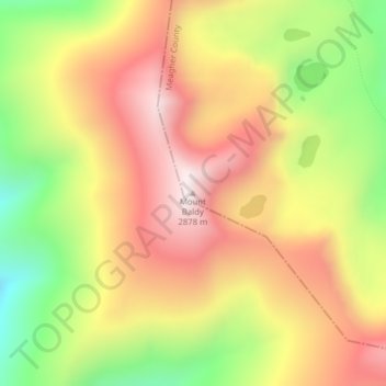
Name: Mount Baldy topographic map, elevation, terrain.
Location: Mount Baldy, Meagher County, Montana, United States (46.44016 -111.24751 46.44026 -111.24741)
Average elevation: 2,532 m
Minimum elevation: 2,114 m
Maximum elevation: 2,881 m
Make a donation
Other topographic maps
Click on a map to view its topography, its elevation and its terrain.
Bozeman
United States > Montana > Gallatin County
Bozeman is located at an elevation of 4,820 feet (1,470 m). The Bridger Mountains are to the north-northeast, the Tobacco Root Mountains to the west-southwest, the Big Belt Mountains and Horseshoe Hills to the northwest, the Hyalite Peaks of the northern Gallatin Range to the south and the Spanish Peaks of the…
Average elevation: 1,495 m
Billings
United States > Montana > Yellowstone County
Two-thirds of the city is in the Yellowstone Valley and the South Hills area and one-third in the Heights-Lockwood area. The city is divided by the Rims, long cliffs, also called the Rimrocks. The Rims run to the north and east of the downtown core, separating it from the Heights to the north and Lockwood to…
Average elevation: 1,027 m
Helena
United States > Montana > Lewis and Clark County
Helena is located at 46°35′45″N 112°1′37″W / 46.59583°N 112.02694°W / 46.59583; -112.02694 (46.595805, −112.027031), at an altitude of 4,058 feet (1,237 m).
Average elevation: 1,301 m
Missoula
United States > Montana > Missoula County
Missoula is located at the western edge of Montana, approximately 45 miles (70 km) from the Idaho border. The city is at an elevation of 3,209 feet (978 m) above sea level, with nearby Mount Sentinel and Mount Jumbo steeply rising to 5,158 feet (1,572 m) and 4,768 feet (1,453 m), respectively. According to the…
Average elevation: 1,173 m
Make a donation
Big Sky
United States > Montana > Gallatin County
Big Sky is characterized by its dramatic and diverse topography, which forms part of the northern Rocky Mountains. The area features an elevation that ranges from around 5,500 feet in the valleys to more than 11,000 feet at its peaks, including the notable Lone Peak. This mountainous terrain is interspersed…
Average elevation: 2,435 m
Kalispell
United States > Montana > Flathead County
Kalispell is located at 48°11′52″N 114°18′58″W / 48.19778°N 114.31611°W / 48.19778; -114.31611 (48.197801, −114.316068), at an elevation of 2,956 feet (901 m).
Average elevation: 934 m
Missoula
United States > Montana > Missoula County
Missoula is located at the western edge of Montana, approximately 45 miles (70 km) from the Idaho border. The city is at an elevation of 3,209 feet (978 m) above sea level, with nearby Mount Sentinel and Mount Jumbo steeply rising to 5,158 feet (1,572 m) and 4,768 feet (1,453 m), respectively. According to the…
Average elevation: 1,173 m
Make a donation
Bozeman
United States > Montana > Gallatin County
Bozeman is located at an elevation of 4,820 feet (1,470 m). The Bridger Mountains are to the north-northeast, the Tobacco Root Mountains to the west-southwest, the Big Belt Mountains and Horseshoe Hills to the northwest, the Hyalite Peaks of the northern Gallatin Range to the south and the Spanish Peaks of the…
Average elevation: 1,495 m
Make a donation
Make a donation
Make a donation
Make a donation
Make a donation
Glacier National Park
One of the most dramatic evidences of this overthrust is visible in the form of Chief Mountain, an isolated peak on the edge of the eastern boundary of the park rising 2,500 feet (800 m) above the Great Plains. There are six mountains in the park over 10,000 feet (3,000 m) in elevation, with Mount Cleveland at…
Average elevation: 1,594 m
Make a donation
Make a donation
Bozeman
United States > Montana > Gallatin County
Bozeman is located at an elevation of 4,820 feet (1,470 m). The Bridger Mountains are to the north-northeast, the Tobacco Root Mountains to the west-southwest, the Big Belt Mountains and Horseshoe Hills to the northwest, the Hyalite Peaks of the northern Gallatin Range to the south and the Spanish Peaks of the…
Average elevation: 1,495 m
Butte
United States > Montana > Silver Bow County
Butte's South district, situated at a lower elevation below the hillside that comprises northern Butte, has historically been home to working-class neighborhoods. Gold mines originally populated south Butte before it was platted for the Union Pacific Railroad in 1881.
Average elevation: 1,909 m
Make a donation
Make a donation
Butte
United States > Montana > Silver Bow County
Butte's South district, at a lower elevation than the hillside that comprises northern Butte, has historically been home to working-class neighborhoods. Gold mines originally populated south Butte before it was platted for the Union Pacific Railroad in 1881.
Average elevation: 1,909 m
Make a donation
Kalispell
United States > Montana > Flathead County
Kalispell is located at 48°11′52″N 114°18′58″W / 48.19778°N 114.31611°W / 48.19778; -114.31611 (48.197801, −114.316068), at an elevation of 2,956 feet (901 m).
Average elevation: 934 m
Gates of the Mountains Wilderness
United States > Montana > Lewis and Clark County
Average elevation: 1,650 m
Make a donation
Make a donation
Make a donation
Missoula
United States > Montana > Missoula County
Missoula is located at the western edge of Montana, less than 25 miles (40 km) from the Idaho border as the crow flies. By highway it is 117 miles (188 km) south of Kalispell, 118 miles (190 km) northwest of Butte and 165 miles (266 km) southeast of Coeur d'Alene, Idaho. The city is at an elevation of 3,209…
Average elevation: 1,173 m
Make a donation
Glacier National Park
One of the most dramatic evidences of this overthrust is visible in the form of Chief Mountain, an isolated peak on the edge of the eastern boundary of the park rising 2,500 feet (800 m) above the Great Plains. There are six mountains in the park over 10,000 feet (3,000 m) in elevation, with Mount Cleveland at…
Average elevation: 1,594 m
Make a donation
Dillon
United States > Montana > Beaverhead County
Dillon is situated on the Beaverhead River. It lies at an elevation of 5,102 feet (1,555 m).
Average elevation: 1,562 m
Make a donation
Butte
United States > Montana > Silver Bow County
Butte's South district, situated at a lower elevation below the hillside that comprises northern Butte, has historically been home to working-class neighborhoods. Gold mines originally populated south Butte before it was platted for the Union Pacific Railroad in 1881.
Average elevation: 1,909 m
Make a donation
Make a donation
Big Sky
United States > Montana > Gallatin County
Big Sky is located close to the Yellowstone National Park along the western edge of Gallatin County and eastern edge of Madison County, on U.S. Highway 191. It is approximately midway between West Yellowstone and Bozeman, being around 45 miles (72 km) by road from each. It sits within the Madison Range, with…
Average elevation: 2,439 m
Make a donation
Make a donation
Red Lodge
United States > Montana > Carbon County
Red Lodge experiences a continental climate (Köppen Dfb) with cold, somewhat dry winters and warm, wetter summers. Summers are cooler than in areas of Montana further north, due to the high elevation. Winters however, are milder than areas further to the east due to the chinook wind influence, as with most of…
Average elevation: 1,720 m
Make a donation
Butte
United States > Montana > Silver Bow County
Butte's South district, at a lower elevation than the hillside that comprises northern Butte, has historically been home to working-class neighborhoods. Gold mines originally populated south Butte before it was platted for the Union Pacific Railroad in 1881.
Average elevation: 1,909 m
Make a donation
Axolotl Lakes Wilderness Study Area
United States > Montana > Madison County
Average elevation: 2,351 m
Make a donation