
Make a donation
North Maluku topographic map
Click on the map to display elevation.
Make a donation
About this map
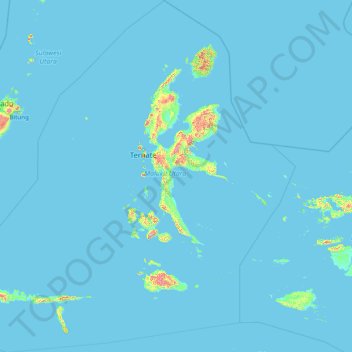
Name: North Maluku topographic map, elevation, terrain.
Location: North Maluku, Maluku, Indonesia (-2.79562 123.92323 3.40760 130.06862)
Average elevation: 19 m
Minimum elevation: 0 m
Maximum elevation: 1,763 m
Make a donation
Other topographic maps
Click on a map to view its topography, its elevation and its terrain.
Make a donation
Make a donation
Tambora
Indonesia > West Nusa Tenggara
Mount Tambora, or Tomboro, is an active stratovolcano in West Nusa Tenggara, Indonesia. Located on Sumbawa in the Lesser Sunda Islands, it was formed by the active subduction zones beneath it. Before 1815, its elevation reached more than 4,300 metres (14,100 feet) high, making it one of the tallest peaks in…
Average elevation: 1,393 m
Make a donation
Make a donation
Make a donation
Bandung
Indonesia > West Java > Bandung
Bandung, the capital of West Java province, located about 180 kilometres (110 mi) southeast of Jakarta, is the third-largest city in Indonesia. Its elevation is 768 metres (2,520 ft) above sea level and is surrounded by up to 2,400 metres (7,900 feet) high Late Tertiary and Quaternary volcanic terrain. The 400…
Average elevation: 879 m
Make a donation
Bogor
The city is situated in the western part of Java island, about 53 km south of the capital Jakarta and 85 km northwest of Bandung, the administrative center of West Java Province. Bogor spreads over a basin near volcanoes Salak, which peaks at about 12 km south, and Mount Gede whose top is 22–25 km south-east…
Average elevation: 442 m
Make a donation
Make a donation
Make a donation
Make a donation
Make a donation
Make a donation
Make a donation
Make a donation
Dadap Kusan Raya
Indonesia > South Kalimantan > Tanah Bumbu > Dadap Kusan Raya
Average elevation: 246 m
Make a donation
Make a donation
Make a donation
Make a donation