
Thank you for supporting this site ❤️
Make a donation
Make a donation
Merseburg topographic map
Click on the map to display elevation.
Thank you for supporting this site ❤️
Make a donation
Make a donation
Merseburg
Zum Stadtgebiet gehören die Orte Merseburg, Annemariental, Atzendorf, Beuna (Geiseltal), Blösien, Elisabethhöhe, Freiimfelde, Geusa, Kötzschen, Meuschau, Neumarkt, Trebnitz, Venenien, Gut Werder und Zscherben.
Thank you for supporting this site ❤️
Make a donation
Make a donation
About this map
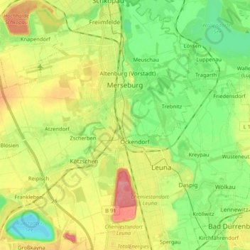
Name: Merseburg topographic map, elevation, terrain.
Location: Merseburg, Saalekreis, Sachsen-Anhalt, 06217, Deutschland (51.29032 11.89835 51.39028 12.03945)
Average elevation: 98 m
Minimum elevation: 62 m
Maximum elevation: 149 m
Thank you for supporting this site ❤️
Make a donation
Make a donation
Other topographic maps
Click on a map to view its topography, its elevation and its terrain.
Thank you for supporting this site ❤️
Make a donation
Make a donation
Thank you for supporting this site ❤️
Make a donation
Make a donation
Thank you for supporting this site ❤️
Make a donation
Make a donation
Thank you for supporting this site ❤️
Make a donation
Make a donation
Thank you for supporting this site ❤️
Make a donation
Make a donation
Niederwünsch
Deutschland > Sachsen-Anhalt > Saalekreis > Mücheln (Geiseltal) > Niederwünsch
Average elevation: 140 m
Thank you for supporting this site ❤️
Make a donation
Make a donation
St. Ulrich
Deutschland > Sachsen-Anhalt > Saalekreis > Mücheln (Geiseltal) > St. Micheln
Average elevation: 157 m