
Make a donation
Denmark topographic map
Click on the map to display elevation.
Make a donation
Denmark
The Kingdom of Denmark, including the Faroe Islands and Greenland, has roughly 1,400 islands greater than 100 square metres (1,100 sq ft) in area; 443 have been named and 78 are inhabited. Denmark's population is over 6 million (1 May 2025), of which roughly 40% live in Zealand, (Sjælland) the largest and most populated island in Denmark proper; Copenhagen, (København) the capital and largest city of the Danish Realm, is situated on Zealand and Amager and Slotsholmen. Composed mostly of flat, arable land, Denmark is characterised by sandy coasts, low elevation, and a temperate climate. Denmark exercises hegemonic influence in the Danish Realm, devolving powers to the other constituent entities to handle their internal affairs. Home rule was established in the Faroe Islands in 1948; Greenland achieved home rule in 1979 and further autonomy in 2009.
Make a donation
About this map
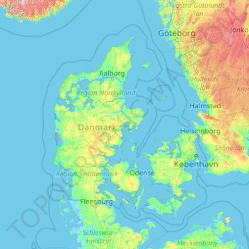
Name: Denmark topographic map, elevation, terrain.
Location: Denmark (54.45167 7.71533 57.95243 15.55306)
Average elevation: 30 m
Minimum elevation: -5 m
Maximum elevation: 598 m
Make a donation
Other topographic maps
Click on a map to view its topography, its elevation and its terrain.
Make a donation
Make a donation
Addis Ababa
Ethiopia > Addis Ababa > Arada
Addis Ababa (/ˌædɪs ˈæbəbə/ AD-iss AB-ə-bə; Amharic: አዲስ አበባ [adˈdis ˈaβəβa] , lit. 'new flower'; Oromo: Finfinnee, lit. 'fountain of hot mineral water') is the capital city of Ethiopia. With an estimated population of 2,739,551 inhabitants as of the 2007 census, it is the largest…
Average elevation: 2,517 m
Make a donation
Kotdwar
India > Uttarakhand > Kotdwara
Kotdwar lies on the western margin of the Himalayas, at an altitude of 454 m (1,490 ft) above sea level.
Average elevation: 641 m
Make a donation
Sinabad
Iran > West Azerbaijan Province > Urumia County > دهستان صومای جنوبی
Average elevation: 1,876 m
Make a donation
Make a donation
Aramoun
Lebanon > Mount Lebanon Governorate
Aramoun (Arabic: عرمون) is a village in the Aley District of Mount Lebanon, Lebanon, lying to the east of Khalde and 22 kilometres away from Beirut. Aramoun's altitude ranges between 250 meters to 600 meters further east. The village has a Druze and Christian community, major families are Yehia, Jawhari,…
Average elevation: 467 m
Corró d'Amunt
Spain > Catalonia > Vallès Oriental > les Franqueses del Vallès
Average elevation: 287 m
Make a donation
Make a donation
Pièce du Moulin
France > Nouvelle-Aquitaine > Charente-Maritime > Le Grand-Village-Plage
Average elevation: 4 m
Make a donation
Make a donation
Make a donation
Make a donation
Make a donation
Sungai Haji Dorani
Malaysia > Selangor > Kampung Sungai Haji Dorani > Kampung Nelayan Sungai Haji Durani
Average elevation: 3 m
Make a donation
Make a donation
Bayang
The topography of the municipality is generally characterized by moderately sloping lands. Approximately 2,606 hectares (63.45%) have moderate slopes of 8 – 15%. Steep lands with a slope 40 – 60% comprise 20.14% (827) ha. About 674 (16.41) have nearly level terrain.
Average elevation: 782 m
San Jose
The municipality is in a valley bounded on the east by the Palusong Mountain Range moving south and on the west by the Hitaasan Mountain Range. The land is generally alluvial flat and swamplands which has an elevation of less than 10 metres (33 ft) above sea level, while going south, south easterly, the…
Average elevation: 15 m
Make a donation
Make a donation
Make a donation
Make a donation
Make a donation
Johannesburg
South Africa > Gauteng > City of Johannesburg Metropolitan Municipality
Johannesburg is located in the eastern plateau area of South Africa known as the Highveld, at an elevation of 1,753 metres (5,751 ft). The former Central Business District is located on the southern side of the prominent ridge called the Witwatersrand (English: White Water's Ridge) and the terrain falls to the…
Average elevation: 1,615 m
Lindridge Park
United Kingdom > England > Devon > Teignbridge > Luton > Humber
Average elevation: 125 m
Make a donation
Sudeley Castle
United Kingdom > England > Gloucestershire > Cheltenham > Sudeley
His elevation almost certainly came from his assistance in the suppression of the Wyatt rebellion.
Average elevation: 135 m
Make a donation
Αβία
Greece > Peloponnese Region > Messenia Regional Unit > Municipal Unit of Avia
Average elevation: 45 m
Make a donation
Worsbrough
United Kingdom > England > Barnsley
On High Street, Worsbrough Dale. The east elevation bears the inscriptions "AD 1903" and "Ebenezer Wesleyan Reform". There are also foundation stones either side of the doorway inscribed with "EBENEZER CHAPEL 1854". This suggests that the chapel was built in 1854 and extended upwards in 1903.
Average elevation: 98 m
Make a donation
Le Plan de l'Envers
France > Auvergne-Rhône-Alpes > Upper Savoy > Vallorcine
Average elevation: 1,721 m
Kampos Marathokampou
Greece > Northern Aegean > Samos Regional Unit > Municipal Unit of Marathokabos
Average elevation: 99 m
Make a donation