
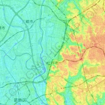
Matsudo topographic map
Interactive map
Click on the map to display elevation.
About this map
Name: Matsudo topographic map, elevation, terrain.
Location: Matsudo, Chiba Prefecture, Japan (35.74672 139.87939 35.84977 140.00136)
Average elevation: 13 m
Minimum elevation: -7 m
Maximum elevation: 37 m
Matsudo is located in the far northwestern corner of Chiba Prefecture, about 20 to 30 kilometers from the prefectural capital at Chiba and 10 to 20 kilometers from downtown Tokyo. The western border of the city is the Edo River, which flows from north to south, and most of the city is on an alluvial plain with an elevation of only around four meters above sea level, with the eastern end rising to 20 to 30 meters on the Shimōsa Plateau. The city has the approximate dimensions of 11.4 kilometers from east-to-west and 11.6 kilometers from north-to-south.
Other topographic maps
Click on a map to view its topography, its elevation and its terrain.
Ozora
Ozora, Abashiri County, Okhotsk Subprefecture, Hokkaido Prefecture, Japan
Average elevation: 113 m
Biratori
Biratori, Saru County, Hidaka Subprefecture, Hokkaido Prefecture, Japan
Average elevation: 185 m
Toshima Island
Toshima Island, Maizuru, Kyoto Prefecture, Japan
Average elevation: 21 m
Niseko
Niseko, Abuta County, Shiribeshi Subprefecture, Hokkaido Prefecture, Japan
Average elevation: 339 m
Noto
Noto, Houshi County, Ishikawa Prefecture, Chubu Region, Japan
Average elevation: 56 m
Kitanakagusuku
Kitanakagusuku, Nakagami, Okinawa Prefecture, Japan
Average elevation: 59 m
Watarase Usuichi
Watarase Usuichi, Tochigi, Tochigi Prefecture, 374-0112, Japan
Average elevation: 18 m
Saza
Saza, Kita-Matsuura County, Nagasaki Prefecture, 857-0322, Japan
Average elevation: 111 m
Arita
Arita, Nishi-Matsuura County, Saga Prefecture, Japan
Average elevation: 184 m
Sagara
Sagara, Kuma County, Kumamoto Prefecture, 868-0094, Japan
Average elevation: 422 m
Nakaniikawa County
Nakaniikawa County, Toyama Prefecture, Chubu Region, Japan
Average elevation: 665 m
Hakone
Hakone, Ashigarashimo County, Kanagawa Prefecture, Japan
Average elevation: 722 m
Furuu County
Furuu County, Shiribeshi Subprefecture, Hokkaido Prefecture, Japan
Average elevation: 124 m
Manazuru
Manazuru, Ashigarashimo County, Kanagawa Prefecture, 259-0201, Japan
Average elevation: 206 m