
French Guiana topographic map
Interactive map
Click on the map to display elevation.
About this map
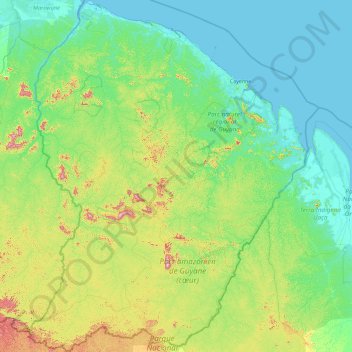
Name: French Guiana topographic map, elevation, terrain.
Location: French Guiana, France (2.11094 -54.60269 5.77695 -51.63461)
Average elevation: 103 m
Minimum elevation: -2 m
Maximum elevation: 791 m
French Guiana has an equatorial climate predominant. Located within six degrees of the Equator and rising only to modest elevations, French Guiana is hot and oppressively humid all year round. During most of the year, rainfall across the country is heavy due to the presence of the Intertropical Convergence Zone and its powerful thunderstorm cells. In most parts of French Guiana, rainfall is always heavy especially from December to July – typically over 330 millimetres or 13 inches can be expected each month during this period throughout the department. Between August and November, the eastern half experiences a warm dry season with rainfall below 100 millimetres or 3.94 inches and average high temperatures above 30 °C (86 °F) occurring in September and October, causing eastern French Guiana to be classified as a tropical monsoon climate (Köppen Am); Saint-Laurent-du-Maroni in the west has a tropical rainforest climate (Af).
Other topographic maps
Click on a map to view its topography, its elevation and its terrain.
Villabé
France > Ile-de-France > Essonne
Villabé, Évry, Essonne, Ile-de-France, Metropolitan France, 91100, France
Average elevation: 64 m
Descartes
France > Centre-Val de Loire > Indre-et-Loire
Descartes, Loches, Indre-et-Loire, Centre-Val de Loire, Metropolitan France, 37160, France
Average elevation: 90 m
Thuir
France > Occitania > Pyrénées-Orientales
Thuir, Céret, Pyrénées-Orientales, Occitania, Metropolitan France, 66300, France
Average elevation: 120 m
Saint-Paul-Mont-Penit
France > Pays de la Loire > Vendée
Saint-Paul-Mont-Penit, La Roche-sur-Yon, Vendée, Pays de la Loire, Metropolitan France, 85670, France
Average elevation: 46 m
Mondron
France > Brittany > Ille-et-Vilaine > Vergéal
Mondron, Vergéal, Fougères-Vitré, Ille-et-Vilaine, Brittany, Metropolitan France, 35680, France
Average elevation: 97 m
Montournais
France > Pays de la Loire > Vendée
Montournais, Fontenay-le-Comte, Vendée, Pays de la Loire, Metropolitan France, 85700, France
Average elevation: 184 m
Indre-et-Loire
Indre-et-Loire, Centre-Val de Loire, Metropolitan France, France
Average elevation: 98 m
Nouâtre
France > Centre-Val de Loire > Indre-et-Loire
Nouâtre, Chinon, Indre-et-Loire, Centre-Val de Loire, Metropolitan France, 37800, France
Average elevation: 64 m
Bourg-en-Bresse
France > Auvergne-Rhône-Alpes > Ain
Bourg-en-Bresse, Ain, Auvergne-Rhône-Alpes, Metropolitan France, 01000, France
Average elevation: 238 m
L'Île-Bouchard
France > Centre-Val de Loire > Indre-et-Loire
L'Île-Bouchard, Chinon, Indre-et-Loire, Centre-Val de Loire, Metropolitan France, 37220, France
Average elevation: 41 m
Bourru
France > Grand Est > Meuse > Saint-Laurent-sur-Othain
Bourru, Saint-Laurent-sur-Othain, Verdun, Meuse, Grand Est, Metropolitan France, 55150, France
Average elevation: 236 m
Les Mousses
France > Centre-Val de Loire > Loiret > Baule
Les Mousses, Baule, Orléans, Loiret, Centre-Val de Loire, Metropolitan France, 45130, France
Average elevation: 96 m
Saint-Pierre-en-Faucigny
France > Auvergne-Rhône-Alpes > Upper Savoy
Saint-Pierre-en-Faucigny, Bonneville, Upper Savoy, Auvergne-Rhône-Alpes, Metropolitan France, 74800, France
Average elevation: 613 m
Saint-Rémy-de-Provence
France > Provence-Alpes-Côte d'Azur > Bouches-du-Rhône
Saint-Rémy-de-Provence, Arles, Bouches-du-Rhône, Provence-Alpes-Côte d'Azur, Metropolitan France, 13210, France
Average elevation: 100 m
La Tourette
France > Auvergne-Rhône-Alpes > Loire
La Tourette, Montbrison, Loire, Auvergne-Rhône-Alpes, Metropolitan France, 42380, France
Average elevation: 775 m
Aire-sur-l'Adour
France > Nouvelle-Aquitaine > Landes
Aire-sur-l'Adour, Mont-de-Marsan, Landes, Nouvelle-Aquitaine, Metropolitan France, 40800, France
Average elevation: 122 m
Éveux
France > Auvergne-Rhône-Alpes > Rhône
Éveux, Villefranche-sur-Saône, Rhône, Auvergne-Rhône-Alpes, Metropolitan France, 69210, France
Average elevation: 320 m
Annecy
France > Auvergne-Rhône-Alpes > Upper Savoy
Annecy, Upper Savoy, Auvergne-Rhône-Alpes, Metropolitan France, France
Average elevation: 610 m
Le Pey
France > Nouvelle-Aquitaine > Dordogne > Thénac
Le Pey, Thénac, Bergerac, Dordogne, Nouvelle-Aquitaine, Metropolitan France, 24240, France
Average elevation: 130 m
Les Estables
France > Auvergne-Rhône-Alpes > Haute-Loire
Les Estables, Le Puy-en-Velay, Haute-Loire, Auvergne-Rhône-Alpes, Metropolitan France, 43150, France
Average elevation: 1,359 m
Saint-Germain-en-Coglès
France > Brittany > Ille-et-Vilaine
Saint-Germain-en-Coglès, Fougères-Vitré, Ille-et-Vilaine, Brittany, Metropolitan France, 35133, France
Average elevation: 142 m
Tikei
France > French Polynesia > Takaroa
Tikei, Takaroa, Tuamotu-Gambier, French Polynesia, France
Average elevation: 0 m
Jura
France > Bourgogne-Franche-Comté
Jura, Bourgogne-Franche-Comté, Metropolitan France, France
Average elevation: 509 m
Le Grand Port
France > Normandy > Manche > Vains
Le Grand Port, Vains, Avranches, Manche, Normandy, Metropolitan France, 50300, France
Average elevation: 12 m
Chaville
France > Ile-de-France > Hauts-de-Seine
Chaville, Boulogne-Billancourt, Hauts-de-Seine, Ile-de-France, Metropolitan France, 92370, France
Average elevation: 127 m
Vallon-Pont-d'Arc
France > Auvergne-Rhône-Alpes > Ardèche
Vallon-Pont-d'Arc, Largentière, Ardèche, Auvergne-Rhône-Alpes, Metropolitan France, 07150, France
Average elevation: 191 m
Sainte-Catherine
France > Hauts-de-France > Pas-de-Calais
Sainte-Catherine, Arras, Pas-de-Calais, Hauts-de-France, Metropolitan France, 62223, France
Average elevation: 82 m
Lozzi
France > Corsica > Haute-Corse
Lozzi, Corte, Haute-Corse, Corsica, Metropolitan France, 20224, France
Average elevation: 1,358 m
Erbajolo
France > Corsica > South Corsica > Conca
Erbajolo, Conca, Sartène, South Corsica, Corsica, Metropolitan France, 20135, France
Average elevation: 264 m
Provence-Alpes-Côte d'Azur
Provence-Alpes-Côte d'Azur, Metropolitan France, France
Average elevation: 665 m
Nord
Nord, Hauts-de-France, Metropolitan France, France
Average elevation: 67 m
Annœullin
France > Hauts-de-France > Nord
Annœullin, Lille, Nord, Hauts-de-France, Metropolitan France, 59112, France
Average elevation: 25 m
Lajat
France > Nouvelle-Aquitaine > Haute-Vienne > Saint-Léonard-de-Noblat
Lajat, Saint-Léonard-de-Noblat, Limoges, Haute-Vienne, Nouvelle-Aquitaine, Metropolitan France, 87400, France
Average elevation: 324 m