
Għajnsielem topographic map
Interactive map
Click on the map to display elevation.
About this map
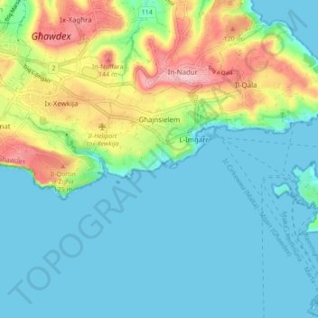
Name: Għajnsielem topographic map, elevation, terrain.
Location: Għajnsielem, Gozo Region, GSM 1931, Malta (36.00380 14.26845 36.03650 14.35330)
Average elevation: 42 m
Minimum elevation: -1 m
Maximum elevation: 161 m
Other topographic maps
Click on a map to view its topography, its elevation and its terrain.