
Thank you for supporting this site ❤️
Make a donation
Make a donation
Bainsville topographic map
Click on the map to display elevation.
Thank you for supporting this site ❤️
Make a donation
Make a donation
About this map
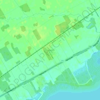
Name: Bainsville topographic map, elevation, terrain.
Average elevation: 50 m
Minimum elevation: 43 m
Maximum elevation: 57 m
Thank you for supporting this site ❤️
Make a donation
Make a donation
Other topographic maps
Click on a map to view its topography, its elevation and its terrain.
Lake Saint-Francis
Canada > Ontario > Stormont, Dundas and Glengarry Counties > South Glengarry
Average elevation: 116 m