
Make a donation
Lake Saint-Francis topographic map
Click on the map to display elevation.
Make a donation
About this map
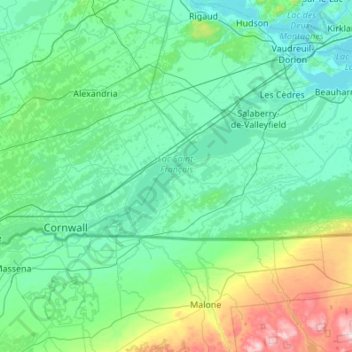
Name: Lake Saint-Francis topographic map, elevation, terrain.
Average elevation: 116 m
Minimum elevation: 18 m
Maximum elevation: 798 m
Make a donation
Other topographic maps
Click on a map to view its topography, its elevation and its terrain.
South Lancaster
Canada > Ontario > Stormont, Dundas and Glengarry Counties > South Glengarry
Average elevation: 47 m
Green Valley
Canada > Ontario > Stormont, Dundas and Glengarry Counties > South Glengarry
Average elevation: 79 m
Brown House Corner
Canada > Ontario > Stormont, Dundas and Glengarry Counties > South Glengarry
Average elevation: 67 m
Martintown
Canada > Ontario > Stormont, Dundas and Glengarry Counties > South Glengarry
Average elevation: 66 m
Make a donation
Summerstown
Canada > Ontario > Stormont, Dundas and Glengarry Counties > South Glengarry
Average elevation: 49 m
Bainsville
Canada > Ontario > Stormont, Dundas and Glengarry Counties > South Glengarry
Average elevation: 50 m
Fraser Point
Canada > Ontario > Stormont, Dundas and Glengarry Counties > South Glengarry
Average elevation: 46 m
Glen Nevis
Canada > Ontario > Stormont, Dundas and Glengarry Counties > South Glengarry
Average elevation: 70 m
Make a donation